IMAGES TAKEN NEAR TO
Mailings Road, GLASGOW, G65 0QP
Introduction
This page details the photographs taken nearby to Mailings Road, G65 0QP by members of the Geograph project.
The Geograph project started in 2005 with the aim of publishing, organising and preserving representative images for every square kilometre of Great Britain, Ireland and the Isle of Man.

There are currently over 7.5m images from over14,400 individuals and you can help contribute to the project by visiting https://www.geograph.org.uk
Image Map
Images are licensed for reuse under creativecommons.org/licenses/by-sa/2.0
Notes
- Clicking on the map will re-center to the selected point.
- The higher the marker number, the further away the image location is from the centre of the postcode.
Image Listing (68 Images Found)
Images are licensed for reuse under creativecommons.org/licenses/by-sa/2.0
Image
Details
Distance
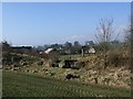
1
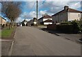
Houses: Mailings Road Banton
An eastward expansion of original village
Image: © Jim Smillie
Taken: 7 Mar 2023
0.02 miles
2
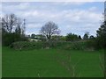
Banton, tramway embankment
Remains of the Banton - Kelvinhead tramway just north of the village.
See RCAHMS site record > http://canmore.rcahms.gov.uk/en/site/45862/details/banton+to+kelvinhead+tramway/
Image: © Robert Murray
Taken: 8 May 2010
0.05 miles
4
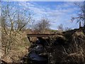
Old Tramway bridge over Craigdouffie Burn
This iron bridge carried the tramway between the ironstone pits west of Mailings to Kelvinhead Jetty on the Forth & Clyde canal a distance of almost 2 kilometres. See related photos www.geograph.org.uk/photo/1736244 and www.geograph.org.uk/photo/1706962
Image: © Robert Murray
Taken: 13 Feb 2010
0.07 miles
5
Tramway bridge over Craigdouffie Burn
This view of the bridge raises questions as the tramway track on either side of the bridge remains are obviously higher than the remaining structure. See related photos www.geograph.org.uk/photo/1706962 and www.geograph.org.uk/photo/1706946
Image: © Robert Murray
Taken: 18 Feb 2010
0.07 miles
6
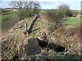
Kelvinhead to Banton tramway
The remains of the bridge over the Craigdoffie Burn. The ironstone workings were situated approx 500 metres up the hill.
The dimensions of the bridge remains left in situ are;
Span between abutments = 3m. Length of remaining girders = 4.5m; The 2 girders are of a double sized type and 460mm wide. The width of the abutments on each side of the burns are approx. 2.3m. With the remaining iron structure only taking up less than 1 metre of the available 2.3m of the abutments it would be fair to assume that the original bridge was wider than the present remains.
See related photos www.geograph.org.uk/photo/1706946 and www.geograph.org.uk/photo/1736244
RCAHMS report http://canmore.rcahms.gov.uk/en/site/45862/details/banton+to+kelvinhead+tramway/
Image: © Robert Murray
Taken: 13 Feb 2010
0.08 miles
7
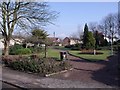
Banton gardens
Another view of these picturesque gardens.
Image: © Robert Murray
Taken: 18 Feb 2010
0.08 miles
8
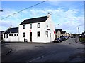
The Swan Inn, Banton
Situated in the heart of the village at the Cross.
Image: © Robert Murray
Taken: 13 Feb 2010
0.08 miles
9
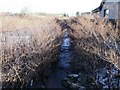
The Craigdouffie Burn at Banton
Another burn which rises in the upper kilsyth Hills. not long after this stretch it joins the Shawend Burn west of the village.
Image: © Robert Murray
Taken: 30 Jan 2010
0.08 miles
10

Public Park, Banton.
A delightfully landscaped and well cared for little park.
Image: © Robert Murray
Taken: 13 Feb 2010
0.09 miles