IMAGES TAKEN NEAR TO
Barrpath, GLASGOW, G65 0EX
Introduction
This page details the photographs taken nearby to Barrpath, G65 0EX by members of the Geograph project.
The Geograph project started in 2005 with the aim of publishing, organising and preserving representative images for every square kilometre of Great Britain, Ireland and the Isle of Man.

There are currently over 7.5m images from over14,400 individuals and you can help contribute to the project by visiting https://www.geograph.org.uk
Image Map
Images are licensed for reuse under creativecommons.org/licenses/by-sa/2.0
Notes
- Clicking on the map will re-center to the selected point.
- The higher the marker number, the further away the image location is from the centre of the postcode.
Image Listing (12 Images Found)
Images are licensed for reuse under creativecommons.org/licenses/by-sa/2.0
Image
Details
Distance
1
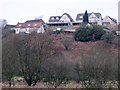
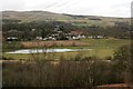
Rooms with views, Kilsyth
Overlooking the upper Kelvin Valley at South Barrwood.
Image: © Robert Murray
Taken: 6 Feb 2010
0.03 miles
2
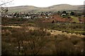
South Barrwood, Kilsyth
Looking across the Kelvin Valley from Craigmarloch Wood towards Barrwood, on the edge of Kilsyth.
Image: © Richard Sutcliffe
Taken: 11 Mar 2020
0.03 miles
3
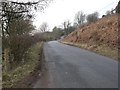
The Coach Road, Kilsyth
Runs along the northern boundary of the Kelvin floodplain.
Image: © Robert Murray
Taken: 6 Feb 2010
0.04 miles
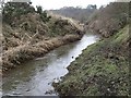
4
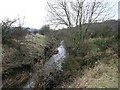
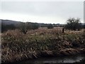
Kelvin Water
The channel flowing west through the valley named after it.
Image: © Robert Murray
Taken: 6 Feb 2010
0.14 miles
5
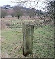
Standing Stone, Kelvin Valley
This might be an old march stone and may predate the straightening of the watercourses in the area which took place in the late 18th. century. The three holes in the side are intriguing.
Image: © Robert Murray
Taken: 6 Feb 2010
0.15 miles
6
Kelvin Water
In the upper Kelvin Valley. After its confluence with the Shawend Burn it becomes far more like the drainage canal it was designed to be.
Image: © Robert Murray
Taken: 6 Feb 2010
0.17 miles
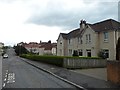
7
St Mirren's Rd, Kilsyth
St Mirren's Rd, Kilsyth typical housing for much of this square
Image: © Jim Bain
Taken: 26 Feb 2006
0.19 miles
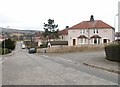
8
Barrwood, Kilsyth
Residential area to the east of the town.
Image: © Stephen Sweeney
Taken: 3 Apr 2012
0.20 miles
9
The upper Kelvin Valley
The Forth & Clyde Canal line is hidden in the distance but the western shoulder of Croy Hill features.
Image: © Robert Murray
Taken: 6 Feb 2010
0.21 miles
10
Barrwood, Kilsyth
Looking across the Kelvin Valley from Craigmarloch Wood towards Barrwood, on the edge of Kilsyth. The field in the middle is still flooded following recent heavy rain.
Image: © Richard Sutcliffe
Taken: 11 Mar 2020
0.22 miles