IMAGES TAKEN NEAR TO
Torrance Road, GLASGOW, G64 4EG
Introduction
This page details the photographs taken nearby to Torrance Road, G64 4EG by members of the Geograph project.
The Geograph project started in 2005 with the aim of publishing, organising and preserving representative images for every square kilometre of Great Britain, Ireland and the Isle of Man.

There are currently over 7.5m images from over14,400 individuals and you can help contribute to the project by visiting https://www.geograph.org.uk
Image Map
Images are licensed for reuse under creativecommons.org/licenses/by-sa/2.0
Notes
- Clicking on the map will re-center to the selected point.
- The higher the marker number, the further away the image location is from the centre of the postcode.
Image Listing (27 Images Found)
Images are licensed for reuse under creativecommons.org/licenses/by-sa/2.0
Image
Details
Distance
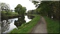
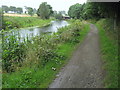
1
Forth and Clyde Canal near Hungryside Bridge, Torrance
Two anglers enjoying September sunshine
Image: © Brian D Osborne
Taken: 20 Sep 2005
0.04 miles
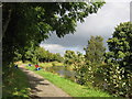
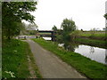
2
Forth and Clyde Canal
View westwards towards Hungryside Bridge.
Image: © Richard Webb
Taken: 9 May 2012
0.04 miles
3
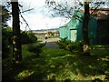
Oil Pumping Station, Hungryside
Although looking like a farm shed, the building is actually a historical pumping station. According to Canmore https://canmore.org.uk/site/164262/hungryside-bridge-oil-pumping-station, the US Navy built an oil pipeline from Old Kilpatrick to Grangemouth at the end of World War I and there were pumping stations at Hungryside and also at Castlecary. See http://historicalrfa.org/57-stories/special/2085-hm-oil-fuel-depot-old-kilpatrick for a fuller description of the pipeline.
Viewed from the Forth and Clyde Canal towpath.
Image: © Richard Sutcliffe
Taken: 6 Oct 2020
0.04 miles
4
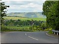
Road to the Kelvin Valley and Torrance
Looking north into the shallow valley of the Kelvin with the Campsie Fells in the distance.
Image: © Robert Murray
Taken: 31 May 2014
0.05 miles
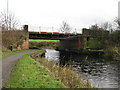
5
Hungryside Bridge
Originally a lifting bridge on the Forth & Clyde Canal, the road deck hinged on the right to allow the masts of boats and sailing ships passage along the canal. Closed in 1962, the canal was reopened again after Millennium funding. The bridge however does not open, it was decided that the clearance from water level to the bridge deck was high enough for recreational purposes.
Image: © Raymond Okonski
Taken: 3 May 2007
0.06 miles
6
Forth and Clyde Canal approaching A807
The canal approaching the main A807 from the east.
Image: © Chris Heaton
Taken: 11 Aug 2009
0.06 miles
7
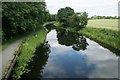
Forth and Clyde Canal
Looking from Hungryside Bridge, which carries the A807, Torrance Road over the Forth and Clyde Canal.
Image: © Richard Sutcliffe
Taken: 14 Jul 2019
0.08 miles
8
Hungryside Bridge
Carries the A807 across the Forth and Clyde Canal.
Image: © G Laird
Taken: 20 Nov 2010
0.08 miles
9
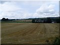
Fields by Bogton Farm
From Torrance Road.
Image: © Stephen Sweeney
Taken: 15 Jul 2009
0.10 miles
10
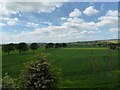
The Kelvin Floodplain
From the A807 at Hungryside Bridge.
Image: © Robert Murray
Taken: 31 May 2014
0.10 miles