IMAGES TAKEN NEAR TO
Colston Avenue, GLASGOW, G64 1SL
Introduction
This page details the photographs taken nearby to Colston Avenue, G64 1SL by members of the Geograph project.
The Geograph project started in 2005 with the aim of publishing, organising and preserving representative images for every square kilometre of Great Britain, Ireland and the Isle of Man.

There are currently over 7.5m images from over14,400 individuals and you can help contribute to the project by visiting https://www.geograph.org.uk
Image Map
Images are licensed for reuse under creativecommons.org/licenses/by-sa/2.0
Notes
- Clicking on the map will re-center to the selected point.
- The higher the marker number, the further away the image location is from the centre of the postcode.
Image Listing (11 Images Found)
Images are licensed for reuse under creativecommons.org/licenses/by-sa/2.0
Image
Details
Distance
1
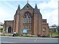
Church of Scotland church on Springburn Road
Image: © Stephen Sweeney
Taken: 27 May 2009
0.04 miles
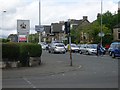
2
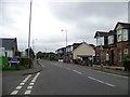
Crossroads at the end of Springburn Road (A803)
Springburn Road continues as Kirkintilloch Road, still the A803, on the other side of the crossroads. Colston Road (B812) crosses at this point.
Image: © G Laird
Taken: 30 Oct 2010
0.07 miles
3

Farmfoods
Frozen food store just off Springburn Road.
Image: © Stephen Sweeney
Taken: 27 May 2009
0.09 miles
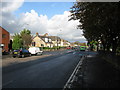
4
Springburn Road becomes Kirkintilloch Road
Just north of Colston Road. Leaving Glasgow and entering East Dunbartonshire.
Image: © Stephen Sweeney
Taken: 27 May 2009
0.10 miles
5
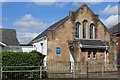
Free Church of Scotland, Auchinairn Road, Bishopbriggs
Image: © Leslie Barrie
Taken: 29 Apr 2014
0.14 miles
7
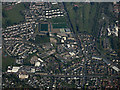
Bishopbriggs from the air
The Arnold Clark car dealership on Kirkintilloch Road is in the foreground. The new Huntershill Community Sports Hub at Auchinairn Road is also prominent.
Image: © Thomas Nugent
Taken: 1 May 2017
0.18 miles
8
Balgrayhill Road
The photograph was taken from the junction with Belmont Road.
The large building on the right was formerly the Marie Curie Hospice (Glasgow). At the time that this picture was taken, the hospice had been relocated to a new building, a little over 300 metres to the north-east, within the grounds of Image
Image: © Lairich Rig
Taken: 11 Oct 2010
0.19 miles
9
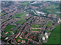
Milton from the air
Milton, on the north side of Glasgow, with the Scaraway Street towerblocks in the lower right and the edge of Possil Loch towards the top right. The Forth & Clyde Canal can also be seen.
Image: © Thomas Nugent
Taken: 9 Jun 2012
0.20 miles
10
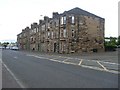
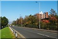
Tenements on Kirkintilloch Road
In Bishopbriggs.
Image: © Stephen Sweeney
Taken: 27 May 2009
0.23 miles