IMAGES TAKEN NEAR TO
Cadder Lane, G64 1FS
Introduction
This page details the photographs taken nearby to Cadder Lane, G64 1FS by members of the Geograph project.
The Geograph project started in 2005 with the aim of publishing, organising and preserving representative images for every square kilometre of Great Britain, Ireland and the Isle of Man.

There are currently over 7.5m images from over14,400 individuals and you can help contribute to the project by visiting https://www.geograph.org.uk
Image Map
Images are licensed for reuse under creativecommons.org/licenses/by-sa/2.0
Notes
- Clicking on the map will re-center to the selected point.
- The higher the marker number, the further away the image location is from the centre of the postcode.
Image Listing (7 Images Found)
Images are licensed for reuse under creativecommons.org/licenses/by-sa/2.0
Image
Details
Distance
1
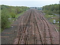
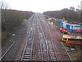
Cadder Yard & Sidings
View along the main line to Lenzie on the Glasgow to Edinburgh inter-city route. Originally this was an important hump-shunted yard, the hump being located to the near left of the picture. Much of these rail workings, including the signal boxes were removed between 1970-1980, and now only provides passing loops on either side of the main line with a few maintenance sidings to the south (right hand) side.
A short goods branch - called Wilderness Plantation spur - started from here and ran south to the Bishopbriggs Oil Depot and onwards to Mavis Valley and its colliery.
Image: © Raymond Okonski
Taken: 22 Apr 2007
0.11 miles
2
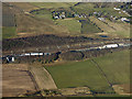
Cadder railway yard from the air
On the outskirts of Bishopbriggs.
Wikipedia https://en.wikipedia.org/wiki/Cadder_Yard .
See also Image
Image: © Thomas Nugent
Taken: 9 Feb 2018
0.15 miles
3
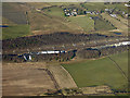
Cadder railway yard from the air
On the outskirts of Bishopbriggs.
Wikipedia https://en.wikipedia.org/wiki/Cadder_Yard .
See also Image
Image: © Thomas Nugent
Taken: 9 Feb 2018
0.15 miles
4
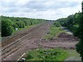
Railway lines in Bishopbriggs
From the Westerhill Road bridge, looking northeast.
Image: © Stephen Sweeney
Taken: 3 Jun 2009
0.20 miles
5
Railway Line at Cadder
Part of the Croy line between Bishopbriggs and Lenzie railway stations viewed from railway bridge number EGM1/109.
Image: © G Laird
Taken: 25 Dec 2013
0.22 miles
6
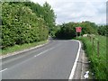
Approaching bend on Westerhill Road
Just south of the railway line near Bishopbriggs.
Image: © Stephen Sweeney
Taken: 3 Jun 2009
0.24 miles
7
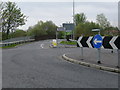
Roundabout at Cadder Sidings
This roundabout (currently unshown on the OS map) was built to remove a dangerous bend as traffic crossed to the north of the Glasgow-Edinburgh railway line, the cost was recovered from Norwich Union who provided a section of land on the perimeter of their property to permit construction, and in return were given permission to build their call centre here. The railway bridge can be seen in the middle-distance, whilst the road continues south to Westerhill Farm.
Image: © Raymond Okonski
Taken: 22 Apr 2007
0.25 miles