IMAGES TAKEN NEAR TO
Mailing Avenue, GLASGOW, G64 1DT
Introduction
This page details the photographs taken nearby to Mailing Avenue, G64 1DT by members of the Geograph project.
The Geograph project started in 2005 with the aim of publishing, organising and preserving representative images for every square kilometre of Great Britain, Ireland and the Isle of Man.

There are currently over 7.5m images from over14,400 individuals and you can help contribute to the project by visiting https://www.geograph.org.uk
Image Map
Images are licensed for reuse under creativecommons.org/licenses/by-sa/2.0
Notes
- Clicking on the map will re-center to the selected point.
- The higher the marker number, the further away the image location is from the centre of the postcode.
Image Listing (10 Images Found)
Images are licensed for reuse under creativecommons.org/licenses/by-sa/2.0
Image
Details
Distance
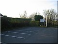
1
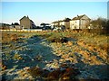
The edge of High Moss
Looking towards the end of Park Road. The overnight frost is slowly disappearing as the sun warms the ground.
Image: © Richard Sutcliffe
Taken: 15 Feb 2019
0.07 miles
2
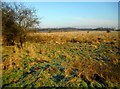
High Moss
This lowland bog is a Local Nature Conservation Site on the edge of Bishopbriggs. In the distance is High Moss Plantation.
Image: © Richard Sutcliffe
Taken: 15 Feb 2019
0.08 miles
3
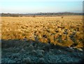
What a difference the sun makes
As the sun rises in the sky over High Moss it is melting the overnight frost. The areas still in shadow have yet to melt. This lowland bog is a Local Nature Conservation Site on the edge of Bishopbriggs.
Image: © Richard Sutcliffe
Taken: 15 Feb 2019
0.08 miles
4
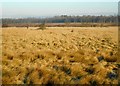
High Moss
This lowland bog is a Local Nature Conservation Site on the edge of Bishopbriggs. In the distance is High Moss Plantation.
Image: © Richard Sutcliffe
Taken: 15 Feb 2019
0.12 miles
5
Church car park
Car park for St Dominics.
Image: © Richard Webb
Taken: 20 Apr 2005
0.17 miles
6
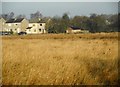
Houses beside High Moss
A zoomed image, looking across grassland at the edge of High Moss (a Local Nature Conservation Site) to houses on the end of Stanley Drive.
Image: © Richard Sutcliffe
Taken: 15 Feb 2019
0.20 miles
7
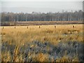
Fence, High Moss
Zoomed image, looking across High Moss (a Local Nature Conservation Site) towards High Moss Plantation.
Image: © Richard Sutcliffe
Taken: 15 Feb 2019
0.20 miles
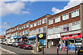
9
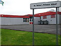
St Helen's Primary School
Situated directly opposite the former Thomas Muir High School (temporarily renamed St Ninian's High School before this is demolished to be replaced by the new Bishopbriggs Academy). This must be the first time that a primary school had its secondary school move closer - albeit temporarily.
Image: © Raymond Okonski
Taken: 22 Apr 2007
0.21 miles
10
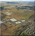
Bishopbriggs from the air
HMP Low Moss and Kirkintilloch are in the background. A new bridge is under construction where Westerhill Road crosses the main Glasgow to Edinburgh, which has recently been electrified.
Image: © Thomas Nugent
Taken: 9 Feb 2018
0.25 miles