IMAGES TAKEN NEAR TO
Killearn, GLASGOW, G63 9PS
Introduction
This page details the photographs taken nearby to G63 9PS by members of the Geograph project.
The Geograph project started in 2005 with the aim of publishing, organising and preserving representative images for every square kilometre of Great Britain, Ireland and the Isle of Man.

There are currently over 7.5m images from over14,400 individuals and you can help contribute to the project by visiting https://www.geograph.org.uk
Image Map
Images are licensed for reuse under creativecommons.org/licenses/by-sa/2.0
Notes
- Clicking on the map will re-center to the selected point.
- The higher the marker number, the further away the image location is from the centre of the postcode.
Image Listing (42 Images Found)
Images are licensed for reuse under creativecommons.org/licenses/by-sa/2.0
Image
Details
Distance
1
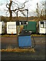
Old fuel pump
At the former Robert Atkinson - Woodside Garage, Killearn.
Image: © Richard Sutcliffe
Taken: 19 Jan 2022
0.02 miles
2
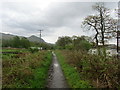
West Highland Way South of Laighparks
Adopting the disused railway that once carried the Blane Valley line between Killearn and Glasgow.
Image: © Chris Heaton
Taken: 12 May 2014
0.02 miles
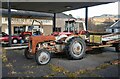
3
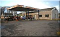
Former garage
Robert Atkinson - Woodside Garage Killearn has been closed for many years. Some of the tractors have been sitting here since at least 2009.
Image: © Richard Sutcliffe
Taken: 19 Jan 2022
0.03 miles
4
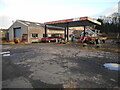
Former garage
Robert Atkinson - Woodside Garage Killearn has been closed for many years. Some of the tractors have been sitting here since at least 2009.
Image: © Richard Sutcliffe
Taken: 19 Jan 2022
0.03 miles
5

Old tractors
At the former Robert Atkinson - Woodside Garage, Killearn. Some of the tractors have been sitting here since at least 2009.
Image: © Richard Sutcliffe
Taken: 19 Jan 2022
0.04 miles
6
Old tractors
At the former Robert Atkinson - Woodside Garage, Killearn. Some of the tractors have been sitting here since at least 2009.
Image: © Richard Sutcliffe
Taken: 19 Jan 2022
0.04 miles
7
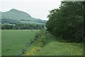
West Highland Way near Dumgoyne
Following the West Highland Way near Dumgoyne.
Image: © Philip Halling
Taken: 7 Jun 1993
0.07 miles
8
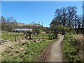
West Highland Way near Woodside House
The path is also part of the John Muir Way. At the far left, seen indistinctly through the trees, is a concrete structure that is part of a Image (the structure can be seen, left of centre, in that view). Nearer, to the left of the gates, is a polytunnel. In the background, Dumgoyne Image is prominent on the edge of the Campsie Hills.
Image: © Lairich Rig
Taken: 18 Apr 2014
0.09 miles
9

A81 North of Dumgoyne
The A81, just to the south of the Oakwood Garden Centre, heading towards Dumgoyne.
Image: © David Dixon
Taken: 20 Apr 2012
0.10 miles
10
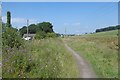
West Highland Way
The route uses the Glasgow to Aberfoyle railway trackbed.
Image: © Richard Webb
Taken: 17 Aug 2016
0.12 miles