IMAGES TAKEN NEAR TO
Station Road, GLASGOW, G63 9PE
Introduction
This page details the photographs taken nearby to Station Road, G63 9PE by members of the Geograph project.
The Geograph project started in 2005 with the aim of publishing, organising and preserving representative images for every square kilometre of Great Britain, Ireland and the Isle of Man.

There are currently over 7.5m images from over14,400 individuals and you can help contribute to the project by visiting https://www.geograph.org.uk
Image Map
Images are licensed for reuse under creativecommons.org/licenses/by-sa/2.0
Notes
- Clicking on the map will re-center to the selected point.
- The higher the marker number, the further away the image location is from the centre of the postcode.
Image Listing (51 Images Found)
Images are licensed for reuse under creativecommons.org/licenses/by-sa/2.0
Image
Details
Distance
1
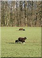
Sheep and lambs
These appear to be Zwartbles sheep, which were first imported from Holland in the early 1990s and have since become established in all areas of the UK and Ireland.
Image: © Richard Sutcliffe
Taken: 27 Jan 2019
0.03 miles
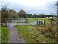
2
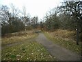
Site of Killearn Station
The site of the former Strathendrick and Aberfoyle Railway's Killearn Station. The line opened in 1882 and closed to passengers in 1951. The route of the line is now part of the West Highland Way.
Image: © Richard Sutcliffe
Taken: 9 Mar 2023
0.04 miles
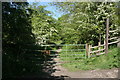
3
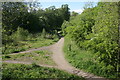
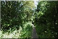
West Highland Way
The long-distance path runs under the B834, from where this photograph was taken. The paths to the left give access to the road itself [http://www.geograph.org.uk/photo/4974916].
Image: © Richard Sutcliffe
Taken: 29 May 2016
0.04 miles
4
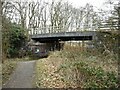
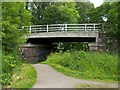
B834 bridge
Crossing the West Highland Way (previously the course of the former Strathendrick and Aberfoyle Railway)
Image: © Richard Sutcliffe
Taken: 9 Mar 2023
0.05 miles
5
West Highland Way near Killearn
At the site of Killearn Station on the railway to Aberfoyle.
Image: © Richard Webb
Taken: 17 Aug 2016
0.06 miles
6
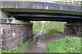
Road bridge over the West Highland Way
At one time the bridge passed over the Balloch–Drymen–Stirling railway line. The line is long gone, but its course is now followed by a section of the West Highland Way.
Killearn Station was located here, just to the north of the bridge; it is depicted on the second-edition OS map (c.1899).
Image: © Lairich Rig
Taken: 30 Jun 2011
0.06 miles
7
The West Highland Way passing beneath the B834
Image: © Tim Heaton
Taken: 12 May 2014
0.06 miles
8
Farm track, Croy Cunningham
There would once have been a level crossing here - photograph taken from a railway trackbed.
Image: © Richard Webb
Taken: 17 Aug 2016
0.07 miles
10
Path to the old railway line
This path leads off the B834 road to Killearn, down to the old disused railway line, that now forms part of the West Highland Way. This was one of the original access routes to Killearn Station which was located at this point.
Image: © Richard Sutcliffe
Taken: 29 May 2016
0.07 miles