IMAGES TAKEN NEAR TO
Moor Road, GLASGOW, G63 9HA
Introduction
This page details the photographs taken nearby to Moor Road, G63 9HA by members of the Geograph project.
The Geograph project started in 2005 with the aim of publishing, organising and preserving representative images for every square kilometre of Great Britain, Ireland and the Isle of Man.

There are currently over 7.5m images from over14,400 individuals and you can help contribute to the project by visiting https://www.geograph.org.uk
Image Map
Images are licensed for reuse under creativecommons.org/licenses/by-sa/2.0
Notes
- Clicking on the map will re-center to the selected point.
- The higher the marker number, the further away the image location is from the centre of the postcode.
Image Listing (12 Images Found)
Images are licensed for reuse under creativecommons.org/licenses/by-sa/2.0
Image
Details
Distance
1
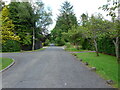
Moor Road, Strathblane
An image to replicate the first submitted for this square in 2005 Image
Image: © Richard Sutcliffe
Taken: 18 Jun 2021
0.03 miles
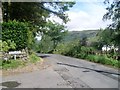
2
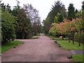
Moor Road, Strathblane
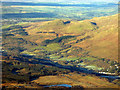
Looking east along Moor Road from just before the open ground of Dumbrock Muir
Image: © Chris Upson
Taken: 5 Oct 2005
0.05 miles
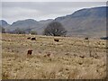
3
Moor Road
Housing estate south of Strathblane, by Dumbrock Muir.
Image: © Stephen Sweeney
Taken: 3 Aug 2010
0.08 miles
5
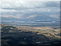
Loch Lomond from the air
Viewed over Strathblane on approach to Glasgow Airport from the north east.
Image: © Thomas Nugent
Taken: 7 Apr 2016
0.17 miles
6
Strathblane and Dumgoyne from the air
Dumbrock Loch is in the foreground. 427m Dumgoyne is the left pinnacle, 426m Dumfoyne is to its right.
Image: © Thomas Nugent
Taken: 11 Dec 2017
0.17 miles
8
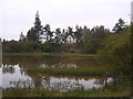
Mill Dam, Strathblane
Looking south across Mill Dam
Image: © Chris Upson
Taken: 5 Oct 2005
0.21 miles
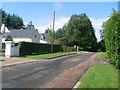
9
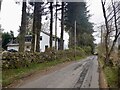
Old Mugdock Road at Moor Road
Near Strathblane.
Image: © Stephen Sweeney
Taken: 3 Aug 2010
0.22 miles
10
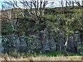
Columnar jointing
This is the northern side of the knoll that is shown on the right in Image; I took the present picture while passing it on the same track; this side was in deep shade, presenting a photographic challenge.
Earlier on the same walk, I had examined another formation, which, though superficially rather different, is a variation on the same theme, and was formed in the same way: Image
More examples can be found a mile or so to the WNW, in the Squirrel Wood: they include Image and Image, but the best example, by far, is the Image
Image: © Lairich Rig
Taken: 18 Apr 2014
0.23 miles