IMAGES TAKEN NEAR TO
Milndavie Road, GLASGOW, G63 9EP
Introduction
This page details the photographs taken nearby to Milndavie Road, G63 9EP by members of the Geograph project.
The Geograph project started in 2005 with the aim of publishing, organising and preserving representative images for every square kilometre of Great Britain, Ireland and the Isle of Man.

There are currently over 7.5m images from over14,400 individuals and you can help contribute to the project by visiting https://www.geograph.org.uk
Image Map
Images are licensed for reuse under creativecommons.org/licenses/by-sa/2.0
Notes
- Clicking on the map will re-center to the selected point.
- The higher the marker number, the further away the image location is from the centre of the postcode.
Image Listing (55 Images Found)
Images are licensed for reuse under creativecommons.org/licenses/by-sa/2.0
Image
Details
Distance
1
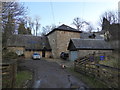
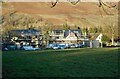
Former mill, Milndavie
Now a dwellinghouse.
Image: © Alpin Stewart
Taken: 1 Jan 2017
0.00 miles
2
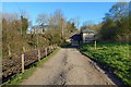
Gowk Stane Road approaching stables
The John Muir Way, which follows this path, turns left near the stables (buildings in left background) to follow a footpath through Milndavie Glen.
For the building that is ahead, a little right of centre, see Image
Image: © Lairich Rig
Taken: 18 Apr 2014
0.04 miles
3
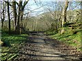
Path through Milndavie Glen
After passing the building shown in Image, the John Muir Way turns left (north), following this path through the woods in Milndavie Glen. The path leads to Dumbrock Road in Strathblane. There is a small marker for the John Muir Way on the wooden gate to the left of the path.
For a view from further along this path, see Image
Image: © Lairich Rig
Taken: 18 Apr 2014
0.06 miles
4
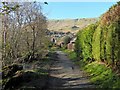
Path through Milndavie Glen
This is a continuation of the path shown in Image Dumbrock Road is not far ahead. At the point where the path meets that road (Image), the John Muir Way turns to the right, heading east along the road: Image
Image: © Lairich Rig
Taken: 18 Apr 2014
0.09 miles
5
New houses
Two new houses being built on Milndavie Road, Strathblane. They occupy a plot which previously held one house.
Image: © Richard Sutcliffe
Taken: 26 Jan 2023
0.11 miles
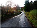
7
Old Mugdock Road
Old Mugdock Road near Mill Dam on a snowy day.
Image: © Dawgy
Taken: 18 Jan 2015
0.13 miles
8
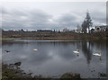
Mill Dam
Mill Dam is a disused dam next to Old Mugdock Road. It is a popular place for swans and geese.
Image: © Dawgy
Taken: 13 Apr 2015
0.13 miles
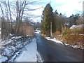
9
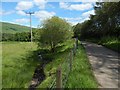
Gowk Stane Road
The 1:25000 map shows the path and the drainage channel beside it; the latter feeds into the Blane Water not far from here.
Image: © Lairich Rig
Taken: 20 Jun 2014
0.13 miles
10
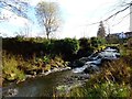
Strathblane, Mill Dam
The spillway - obviously still functioning as intended.
Image: © Robert Murray
Taken: 1 Nov 2011
0.13 miles