IMAGES TAKEN NEAR TO
Dumbrock Drive, GLASGOW, G63 9DN
Introduction
This page details the photographs taken nearby to Dumbrock Drive, G63 9DN by members of the Geograph project.
The Geograph project started in 2005 with the aim of publishing, organising and preserving representative images for every square kilometre of Great Britain, Ireland and the Isle of Man.

There are currently over 7.5m images from over14,400 individuals and you can help contribute to the project by visiting https://www.geograph.org.uk
Image Map
Images are licensed for reuse under creativecommons.org/licenses/by-sa/2.0
Notes
- Clicking on the map will re-center to the selected point.
- The higher the marker number, the further away the image location is from the centre of the postcode.
Image Listing (94 Images Found)
Images are licensed for reuse under creativecommons.org/licenses/by-sa/2.0
Image
Details
Distance
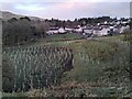
1
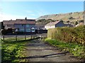
Path meeting Dumbrock Road
The John Muir Way follows a Image (see also Image), which meets Dumbrock Road at this point, in Strathblane. The route then takes a right turn to follow the road eastwards: Image
The edge of the Campsie Hills is prominent in the background.
Image: © Lairich Rig
Taken: 18 Apr 2014
0.04 miles
2
Supporting Ukraine
A Ukrainian flag flying outside a house in Dumbrock Crescent, Strathblane in support of Ukrainians, following the invasion of the country by Russia in February 2022.
Image: © Richard Sutcliffe
Taken: 16 Apr 2022
0.04 miles
3
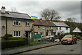
Houses on Dumbrock Road, Strathblane
Some of the properties here have solar panels on their roofs.
Image: © Richard Sutcliffe
Taken: 18 Apr 2023
0.04 miles
5
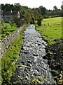
New fence across the lade
New fencing has recently been installed around the perimeter of the Strathblane Wildlife Sanctuary, and many trees planted. This barrier is to prevent livestock which might get into the burn from getting in, while letting the water flow freely.
The lade brings water from the Mill Dam (about 450m to the south). The water originally fed Milndavie Mill (a corn mill, but also a sawmill from the 1870s). It flows into the Blane Water.
Image: © Richard Sutcliffe
Taken: 12 May 2022
0.05 miles
6
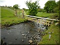
Footbridge over the Blane Water
The path is one of those connecting Strathblane and Blanefield.
Image: © Richard Sutcliffe
Taken: 3 Jan 2022
0.05 miles
7
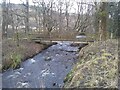
Old mill lade
This lade brings water from the Mill Dam (about 500m to the south). The water originally fed Milndavie Mill (a corn mill, but also a sawmill from the 1870s). It flows into the Blane Water just behind the photographer.
Image: © Richard Sutcliffe
Taken: 10 Oct 2021
0.05 miles
8
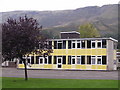
Strathblane Primary School
Slackdhu in the background
Image: © Chris Upson
Taken: 5 Oct 2005
0.06 miles
9
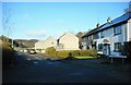
New trees
Some of the 1,000 trees recently planted by volunteers at the Strathblane Wildlife Sanctuary. The nearest houses are on Dumbrock Drive and Park Place.
Image: © Richard Sutcliffe
Taken: 17 Mar 2022
0.08 miles
10
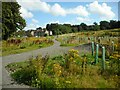
Strathblane Wildlife Sanctury
A path has recently been constructed within the Strathblane Wildlife Sanctuary. This provides good access to the top of the slope, providing views over the sanctuary and over Strathblane village. The green tubes are protecting newly planted trees and ragwort is abundant.
Image: © Richard Sutcliffe
Taken: 20 Aug 2022
0.09 miles