IMAGES TAKEN NEAR TO
Dumbrock Road, GLASGOW, G63 9DG
Introduction
This page details the photographs taken nearby to Dumbrock Road, G63 9DG by members of the Geograph project.
The Geograph project started in 2005 with the aim of publishing, organising and preserving representative images for every square kilometre of Great Britain, Ireland and the Isle of Man.

There are currently over 7.5m images from over14,400 individuals and you can help contribute to the project by visiting https://www.geograph.org.uk
Image Map
Images are licensed for reuse under creativecommons.org/licenses/by-sa/2.0
Notes
- Clicking on the map will re-center to the selected point.
- The higher the marker number, the further away the image location is from the centre of the postcode.
Image Listing (107 Images Found)
Images are licensed for reuse under creativecommons.org/licenses/by-sa/2.0
Image
Details
Distance
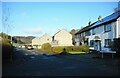
1
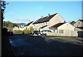
Houses on Dumbrock Road, Strathblane
Some of the properties here have solar panels on their roofs.
Image: © Richard Sutcliffe
Taken: 18 Apr 2023
0.02 miles
2
Path meeting Dumbrock Road
The John Muir Way follows a Image (see also Image), which meets Dumbrock Road at this point, in Strathblane. The route then takes a right turn to follow the road eastwards: Image
The edge of the Campsie Hills is prominent in the background.
Image: © Lairich Rig
Taken: 18 Apr 2014
0.05 miles
3
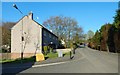
Dumbrock Road, Strathblane
Dumbrock Road is on the right; in the left foreground is its junction with Kirkburn Road. From the point shown in Image, the John Muir Way follows Dumbrock Road eastwards until is meets Glasgow Road (the A81); the route then turns left (north) to follow that road: Image
Image: © Lairich Rig
Taken: 18 Apr 2014
0.06 miles
4
Supporting Ukraine
A Ukrainian flag flying outside a house in Dumbrock Crescent, Strathblane in support of Ukrainians, following the invasion of the country by Russia in February 2022.
Image: © Richard Sutcliffe
Taken: 16 Apr 2022
0.06 miles
6
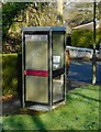
Former telephone kiosk
Beside Dumbrock Road. Now disused.
Image: © Richard Sutcliffe
Taken: 18 Apr 2023
0.07 miles
7
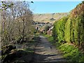
Path through Milndavie Glen
This is a continuation of the path shown in Image Dumbrock Road is not far ahead. At the point where the path meets that road (Image), the John Muir Way turns to the right, heading east along the road: Image
Image: © Lairich Rig
Taken: 18 Apr 2014
0.08 miles
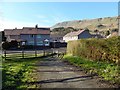
8
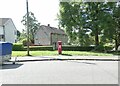
The bottom of Old Mugdock Road
Opposite the post office Image is a priority postbox Image and behind that are some semi-detached houses on Dumbrock Road.
Image: © Gerald England
Taken: 28 Jul 2024
0.08 miles
9
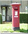
Postbox (G63 612)
Image: © Gerald England
Taken: 28 Jul 2024
0.08 miles
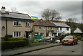
10
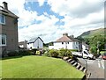
Houses in Strathblane
On the corner of Milndavie Crescent and Old Mugdock Road.
Image: © Gerald England
Taken: 28 Jul 2024
0.08 miles