IMAGES TAKEN NEAR TO
Blanefield, GLASGOW, G63 9AW
Introduction
This page details the photographs taken nearby to G63 9AW by members of the Geograph project.
The Geograph project started in 2005 with the aim of publishing, organising and preserving representative images for every square kilometre of Great Britain, Ireland and the Isle of Man.

There are currently over 7.5m images from over14,400 individuals and you can help contribute to the project by visiting https://www.geograph.org.uk
Image Map
Images are licensed for reuse under creativecommons.org/licenses/by-sa/2.0
Notes
- Clicking on the map will re-center to the selected point.
- The higher the marker number, the further away the image location is from the centre of the postcode.
Image Listing (5 Images Found)
Images are licensed for reuse under creativecommons.org/licenses/by-sa/2.0
Image
Details
Distance
1
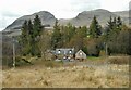
East Arlehaven
Farmstead dating from some time before 1865. In the background are the volcanic plugs of Dumgoyne (427m) and Dumfoyn (426m).
Image: © Richard Sutcliffe
Taken: 16 Apr 2022
0.01 miles
2
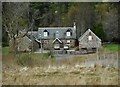
East Arlehaven
Farmstead dating from some time before 1865.
Image: © Richard Sutcliffe
Taken: 16 Apr 2022
0.01 miles
3
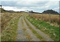
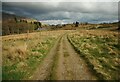
Track near East Arlehaven
Looking west northwest. The wooded hill in the distance is Dumgoyach.
Image: © Richard Sutcliffe
Taken: 16 Apr 2022
0.16 miles
4
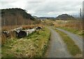
Old logs beside the track
A good place to sit and rest and have a drink. Dumgoyach is in the distance.
Image: © Richard Sutcliffe
Taken: 16 Apr 2022
0.17 miles
5
Track approaching East Arlehaven
East Arlehaven is beside the trees to the left.
Image: © Richard Sutcliffe
Taken: 16 Apr 2022
0.20 miles