IMAGES TAKEN NEAR TO
Blanefield, GLASGOW, G63 9AS
Introduction
This page details the photographs taken nearby to G63 9AS by members of the Geograph project.
The Geograph project started in 2005 with the aim of publishing, organising and preserving representative images for every square kilometre of Great Britain, Ireland and the Isle of Man.

There are currently over 7.5m images from over14,400 individuals and you can help contribute to the project by visiting https://www.geograph.org.uk
Image Map
Images are licensed for reuse under creativecommons.org/licenses/by-sa/2.0
Notes
- Clicking on the map will re-center to the selected point.
- The higher the marker number, the further away the image location is from the centre of the postcode.
Image Listing (35 Images Found)
Images are licensed for reuse under creativecommons.org/licenses/by-sa/2.0
Image
Details
Distance

2
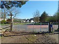
West Highland Way at Easter Carbeth
The West Highland Way and the John Muir Way coincide in this area; there is a small purple-and-white marker for the John Muir Way on the upper part of the signpost.
Both routes follow a path southwards up to this gate, where they meet the main road(*). They then turn left, following the road eastwards for a distance of about 300 metres: see Image, taken beside the same gate. The routes then leave the road again at Image, near which point the John Muir Way and the West Highland Way separate: Image
In this view, the buildings of Easter Carbeth Farm can be seen across the road. For a view in the opposite direction, looking across this gate from the other side, see Image
(*) At the time of writing, large-scale OS mapping calls this part of the road Ballachalairy Yett. I believe this to be a mistake. Early OS maps employed the name correctly (Image), but at some point since then, someone, most likely not knowing that "yett" is Scots for "gate", has misunderstood the name as applying to the road.
Image: © Lairich Rig
Taken: 18 Apr 2014
0.05 miles
3
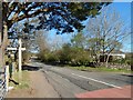
West Highland Way at Easter Carbeth
The gate is the one shown in Image; as noted there, the West Highland Way and the John Muir Way (their routes coincide in this area) meet the main road at this gate. From here, they follow the road for a distance of about 300 metres, before leaving the road again at Image
I was heading in the direction of view of this picture, while almost all walkers were travelling in the opposite direction; many of them will have been following the West Highland Way. The John Muir Way, part of which I was following on this occasion, would be officially opened three days after this picture was taken.
Image: © Lairich Rig
Taken: 18 Apr 2014
0.06 miles
4
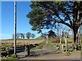
West Highland Way at Easter Carbeth
See Image, a view in the opposite direction from the other side of the gate. In the present picture, the West Highland Way and the John Muir Way (whose routes coincide in this area) leave the main road opposite Easter Carbeth Farm.
Image: © Lairich Rig
Taken: 18 Apr 2014
0.06 miles
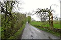
5

Point where the West Highland Way leaves the road at Carbeth
Image: © Peter S
Taken: 31 May 2014
0.08 miles
6
The B821 near Carbeth Loch
Used by the West Highland Way for a few hundred yards.
Image: © Tim Heaton
Taken: 12 May 2014
0.08 miles
7
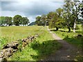
The West Highland Way near Easter Carbeth
The photograph is a counterpart of the more wintry Image Dumgoyne (Image) is visible in the distance, to the left of the path.
This part of the route, set between two dry-stone walls (as shown on the map and in this picture), was known as Tinker's Loan, as mentioned in Jimmie Macgregor's book "On the West Highland Way" (1985).
Image: © Lairich Rig
Taken: 30 Jun 2011
0.09 miles

9
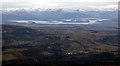
Loch Lomond from the air
Looking over Stockie Muir and Auchengillan to the loch, its islands and the snow capped hills beyond.
Image: © Thomas Nugent
Taken: 1 Dec 2017
0.11 miles
10
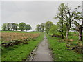
West Highland Way near Easter Carbeth
The trail heading north from the B821 - seen here on a drizzle afflicted day
Image: © Chris Heaton
Taken: 12 May 2014
0.13 miles