IMAGES TAKEN NEAR TO
Blanefield, GLASGOW, G63 9AP
Introduction
This page details the photographs taken nearby to G63 9AP by members of the Geograph project.
The Geograph project started in 2005 with the aim of publishing, organising and preserving representative images for every square kilometre of Great Britain, Ireland and the Isle of Man.

There are currently over 7.5m images from over14,400 individuals and you can help contribute to the project by visiting https://www.geograph.org.uk
Image Map
Images are licensed for reuse under creativecommons.org/licenses/by-sa/2.0
Notes
- Clicking on the map will re-center to the selected point.
- The higher the marker number, the further away the image location is from the centre of the postcode.
Image Listing (23 Images Found)
Images are licensed for reuse under creativecommons.org/licenses/by-sa/2.0
Image
Details
Distance
1
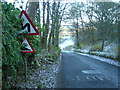
Steep Hill
Steep hill on Carbeth to Blanefield road
Image: © Iain Thompson
Taken: 18 Nov 2005
0.05 miles
2
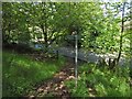
The end of a path
This is the other end of the public footpath whose beginning is shown in Image Here, it meets the B821 near Braehead. See Image for a view in the opposite direction, and for the text of the signpost.
Image: © Lairich Rig
Taken: 20 Jun 2014
0.05 miles
3
The start of a path
The picture was taken from the road (B821). The same area is shown, viewed in the opposite direction, in Image The sign reads: "Public footpath to Mugdock Country Park".
The path leads through the Squirrel Wood, emerging from it at the point shown in Image, where it meets the Gowk Stane Road, or Boards Farm Road.
Image: © Lairich Rig
Taken: 20 Jun 2014
0.06 miles
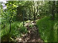
5
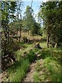
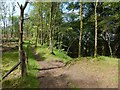
Path through the Squirrel Wood
This path, which is not marked on the map, is a continuation of the one shown on the left in Image See Image for a view in the opposite direction, from further along the path.
Image: © Lairich Rig
Taken: 20 Jun 2014
0.13 miles
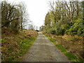
6
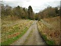
Track near Ardoch House
Looking in the direction of Strathblane.
Image: © Richard Sutcliffe
Taken: 16 Apr 2022
0.14 miles
7
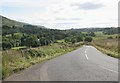
Ballachalairy Yett
Well, that's what is says on the map. Also known as the B821. But see [http://www.geograph.org.uk/photo/2497355] for more information.
Looking towards Strathblane.
Image: © Richard Sutcliffe
Taken: 5 Sep 2015
0.14 miles
8
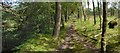
Path through the Squirrel Wood
The ground falls away precipitously to the left (north) of the path, as also indicated by the contours on the map (best seen at 1:25000).
For a view in the opposite direction along a nearby part of the same path, see Image
Image: © Lairich Rig
Taken: 20 Jun 2014
0.14 miles
9
Paths in the Squirrel Wood
A signposted route leading from beside Boards Farm (see Image) to the B821 enters at the lower edge of the photograph, and then, as indicated by the small marker on the post, turns right, to follow a route that, in this picture, immediately dips out of sight; there, it passes the top of Image
Image, which does not appear in the picture, is directly to the left of the photographer's position.
The path that is visible on the left is not a part of the public footpath to the B821. It leads, instead, past the top of Image, before coming to a dead end.
Image: © Lairich Rig
Taken: 20 Jun 2014
0.14 miles
10
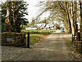
Ardoch House
Advertised as 'boutique hotel and retreat' and 'West Highland Way hotel and campsite'.
Image: © Richard Sutcliffe
Taken: 16 Apr 2022
0.15 miles