IMAGES TAKEN NEAR TO
Crow Road, GLASGOW, G63 0XJ
Introduction
This page details the photographs taken nearby to Crow Road, G63 0XJ by members of the Geograph project.
The Geograph project started in 2005 with the aim of publishing, organising and preserving representative images for every square kilometre of Great Britain, Ireland and the Isle of Man.

There are currently over 7.5m images from over14,400 individuals and you can help contribute to the project by visiting https://www.geograph.org.uk
Image Map
Images are licensed for reuse under creativecommons.org/licenses/by-sa/2.0
Notes
- Clicking on the map will re-center to the selected point.
- The higher the marker number, the further away the image location is from the centre of the postcode.
Image Listing (7 Images Found)
Images are licensed for reuse under creativecommons.org/licenses/by-sa/2.0
Image
Details
Distance
1
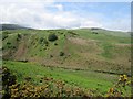
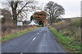
Gonachan Burn
A burn descends to the Endrick off the Campsie Fells. View from the Crow Road.
Image: © Richard Webb
Taken: 1 Jun 2012
0.15 miles
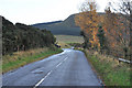
4

Hamlet in the Endrick Valley
The settlement is located around the bridge carrying the B818 over the Endrick Water.
Image: © Richard Sutcliffe
Taken: 28 Mar 2022
0.20 miles
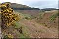
5
View towards the Campsie Fells
View southwest from the B818.
Image: © Richard Webb
Taken: 18 Sep 2015
0.24 miles
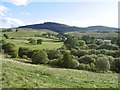
7
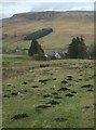
Lurg and the Fintry Hills
Seen from the B822 at the roadend to Townhead. A small conifer plantation sits below Double Craigs at the southwest end of the Fintry Hills. The grassland in the foreground is full of molehills.
Image: © Richard Sutcliffe
Taken: 29 Jan 2017
0.25 miles