IMAGES TAKEN NEAR TO
Balfron, GLASGOW, G63 0QF
Introduction
This page details the photographs taken nearby to G63 0QF by members of the Geograph project.
The Geograph project started in 2005 with the aim of publishing, organising and preserving representative images for every square kilometre of Great Britain, Ireland and the Isle of Man.

There are currently over 7.5m images from over14,400 individuals and you can help contribute to the project by visiting https://www.geograph.org.uk
Image Map
Images are licensed for reuse under creativecommons.org/licenses/by-sa/2.0
Notes
- Clicking on the map will re-center to the selected point.
- The higher the marker number, the further away the image location is from the centre of the postcode.
Image Listing (11 Images Found)
Images are licensed for reuse under creativecommons.org/licenses/by-sa/2.0
Image
Details
Distance
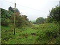
3
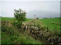
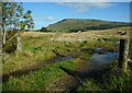
Hill of Balgair
Dyke junction amongst grassland below the less fertile lands of Balgair Muir. The distant hill is Stronend above Fintry.
Image: © Richard Webb
Taken: 17 Sep 2006
0.03 miles
5
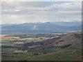
Strath Endrick viewed from Meikle Bin
Various hills of the southern Highlands can be seen beyond the flat lands of Strath Endrick. Stob Binnein and Ben More near Crianlarich are amongst the hills which have caught an early-season covering of snow.
Image: © Alan O'Dowd
Taken: 28 Oct 2019
0.06 miles
8
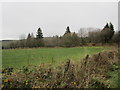
Balgair
Burn running off Balgair Moor. A damp morning but still showing off a fine berry crop.
Image: © Richard Webb
Taken: 17 Sep 2006
0.17 miles