IMAGES TAKEN NEAR TO
Inchmurrin Island, GLASGOW, G63 0JY
Introduction
This page details the photographs taken nearby to Inchmurrin Island, G63 0JY by members of the Geograph project.
The Geograph project started in 2005 with the aim of publishing, organising and preserving representative images for every square kilometre of Great Britain, Ireland and the Isle of Man.

There are currently over 7.5m images from over14,400 individuals and you can help contribute to the project by visiting https://www.geograph.org.uk
Image Map
Images are licensed for reuse under creativecommons.org/licenses/by-sa/2.0
Notes
- Clicking on the map will re-center to the selected point.
- The higher the marker number, the further away the image location is from the centre of the postcode.
Image Listing (17 Images Found)
Images are licensed for reuse under creativecommons.org/licenses/by-sa/2.0
Image
Details
Distance
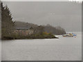
1
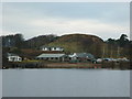
The southern tip of Inchmurrin, Loch Lomond
Inchmurrin is the largest of the 24 islands on Loch Lomond.
Image: © Ian S
Taken: 29 Jan 2011
0.06 miles
2
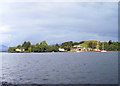
Inchmurran Island headland South West part towards pier
Image: © John Firth
Taken: 29 Sep 2003
0.08 miles
3
Inchmurrin Island, the Ruins of Lennox Castle
Inchmurrin (Scottish Gaelic: Innis Mhearain) is the largest inland island in Britain and the most southerly on Loch Lomond. It gets its name from the chapel to St Mirren that was once on the island. The ruins of the 14th century castle built by Duncan the Eighth Earl of Lennox are at the southwest tip of the island. The castle is recorded as having been completed by 1393 and the Earls of Lennox took up residence in the 14th century when they moved from their castle in Balloch during the plague.
Image: © David Dixon
Taken: 26 Sep 2019
0.08 miles
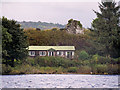
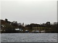
4
Building on Inchmurrin
Lodge type building under the shadow of a ruined castle. On the left is a sign indicating the presence of an underwater cable.
Image: © Gerald England
Taken: 21 Mar 2017
0.09 miles
5
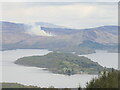
Inchmurrin
Largest island in Loch Lomond and one of a chain along the Highland Boundary Fault. There was a fire beside Conic Hill.
Image: © Richard Webb
Taken: 26 Apr 2022
0.09 miles
6
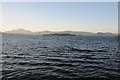
Loch Lomond
Loch Lomond and the island of Inchmurrin in the centre in the middle distance. The mountain on the left in the distance is Ben Lomond, the most southerly Munro (3000 ft+) mountain in Scotland.
Image: © Philip Halling
Taken: 27 Jun 2019
0.09 miles
7
Inchmurrin Island southwestern end pier.
Image: © Johnny Durnan
Taken: 15 Jul 2006
0.09 miles
8
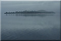
Inchmurrin
A still misty morning on Loch Lomond. Inchmurrin is the largest island on the loch. The name is derived from St. Mirin, an Irish monk who came to Scotland in the first century. The island was the site of a chapel dedicated to the saint.
Image: © Mick Garratt
Taken: 26 Aug 2017
0.10 miles
9
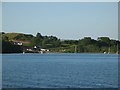
Pier at Inchmurrin
The southernmost of the islands in Loch Lomond.
Image: © Gerald England
Taken: 21 Mar 2017
0.11 miles
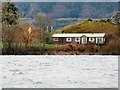
10
Inchmurrin, Loch Lomond
Inchmurrin is the largest of the islands in Loch Lomond. It is privately owned and has a small farm, hotel and restaurant and several holiday chalets.
Image: © David Dixon
Taken: 19 Apr 2012
0.12 miles