IMAGES TAKEN NEAR TO
Croftamie, GLASGOW, G63 0HG
Introduction
This page details the photographs taken nearby to G63 0HG by members of the Geograph project.
The Geograph project started in 2005 with the aim of publishing, organising and preserving representative images for every square kilometre of Great Britain, Ireland and the Isle of Man.

There are currently over 7.5m images from over14,400 individuals and you can help contribute to the project by visiting https://www.geograph.org.uk
Image Map
Images are licensed for reuse under creativecommons.org/licenses/by-sa/2.0
Notes
- Clicking on the map will re-center to the selected point.
- The higher the marker number, the further away the image location is from the centre of the postcode.
Image Listing (21 Images Found)
Images are licensed for reuse under creativecommons.org/licenses/by-sa/2.0
Image
Details
Distance
1
Minor road heading towards Cattermuir
Looking south-westward from the entrance to Catterburn.
Image: © Peter Wood
Taken: 25 Jul 2020
0.10 miles
2
Cattermuir Crossing
The Forth and Clyde Junction Railway crossed the road at this point; nothing now remains of the level crossing. The cottage at the corner was the gatehouse associated with the crossing.
Stewart Noble, in his book "The Vanished Railways of Old Western Dunbartonshire" (2010), mentions that the cottage was given to one of the navvies who had helped to build the line, on the condition that his family operate the gates of the level crossing. In 1930, the navvy's grandson(*), moved out of the cottage and into a nearby hut (shown in Image and Image), which had originally been one of the railway line's parcels vans. He built the chimney that can be seen on the hut, for his coal fire. He lived in the hut until 1971, in which year he bought the cottage.
(*) The book names the occupant "John Smith", but an email correspondent assures me that he was in fact called John Blair; he adds that the cottage was thereafter bought by Ms Brenda Fraser (who died in early 2020), and that it is now (as of December 2020) unoccupied. I am grateful for these corrections and additions.
Out of shot to the left is a long mound that indicates the former course of the line; it is shown separately in Image
Image: © Lairich Rig
Taken: 30 Mar 2012
0.12 miles
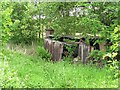
3
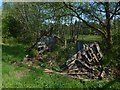
Ruined trackside hut
The hut at Image has an interesting history, but it is now entirely ruined. Earlier pictures: Image / Image
Image: © Lairich Rig
Taken: 17 May 2019
0.12 miles
4
Trackside hut, Forth and Clyde Junction Railway
Remains of one of the trackside huts. The railway closed in 1959.
Image: © Richard Webb
Taken: 15 Jun 2010
0.12 miles
5
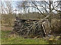
Trackside hut
The ruin is also depicted in another contributor's earlier photograph: Image In the present picture, it appears to be near its final collapse (for which, see Image, taken in 2019).
It is located beside Image, on the course of the dismantled railway line (see the end-note). Unlikely though it might now seem, this former Forth and Clyde Junction Railway parcels van used as to be somebody's home; the chimney that can be seen built onto the hut is an addition made in that period. See Image for further details. Page 102 of the book that is cited there includes two photographs of the hut.
Image: © Lairich Rig
Taken: 1 Apr 2013
0.13 miles
6
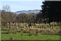
Dismantled railway line
The linear mound behind the fence is what remains of the course of the Forth and Clyde Junction Railway: Image The ventilation shaft cover, one of several to be seen along the length of the mound, is a reminder that it now carries water: see Image and Image
Compare Image and Image
Part of the escarpment of the Campsie Hills can be seen in the background.
Image: © Lairich Rig
Taken: 30 Mar 2012
0.14 miles
7
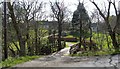
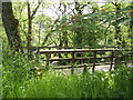
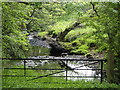
Wooden bridge at Millfaid
The bridge crosses the Catter Burn, and provides access to Image (visible in the background) from the main road; for an earlier picture, see Image
Image: © Lairich Rig
Taken: 30 Mar 2012
0.15 miles
9
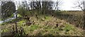
Course of dismantled railway line
The former course of the Forth and Clyde Junction Railway is indicated by a long mound. At this point, just across the road from a house called Image, it is easily accessible, but overgrown. The mound fills the width of the lower edge of the image, and recedes directly from the photographer's position. It is soon obscured from view by trees, but the continuation of the line beyond those trees is shown in Image
Behind the photographer's position, the line used to cross the road: Image
Image: © Lairich Rig
Taken: 30 Mar 2012
0.16 miles