IMAGES TAKEN NEAR TO
Croftamie, GLASGOW, G63 0FF
Introduction
This page details the photographs taken nearby to G63 0FF by members of the Geograph project.
The Geograph project started in 2005 with the aim of publishing, organising and preserving representative images for every square kilometre of Great Britain, Ireland and the Isle of Man.

There are currently over 7.5m images from over14,400 individuals and you can help contribute to the project by visiting https://www.geograph.org.uk
Image Map
Images are licensed for reuse under creativecommons.org/licenses/by-sa/2.0
Notes
- Clicking on the map will re-center to the selected point.
- The higher the marker number, the further away the image location is from the centre of the postcode.
Image Listing (15 Images Found)
Images are licensed for reuse under creativecommons.org/licenses/by-sa/2.0
Image
Details
Distance
1
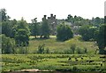
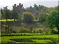
Dalnair House
Seen from the Endrick Viaduct. A Category B listed baronial mansion http://portal.historicenvironment.scot/designation/LB49000 dating from 1884. It is also known as Dalnair Castle. It has recently been extensively renovated as a residential development of 10 luxury apartments.
Image: © Richard Sutcliffe
Taken: 2 Jul 2021
0.09 miles
2
Dalnair House
Seen from the Endrick Viaduct. A Category B listed baronial mansion http://portal.historicenvironment.scot/designation/LB49000 dating from 1884. It is also known as Dalnair Castle. It has recently been extensively renovated as a residential development of 10 luxury apartments.
Image: © Richard Sutcliffe
Taken: 20 Sep 2021
0.09 miles
3
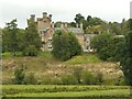
Dalnair House
Category B listed https://portal.historicenvironment.scot/apex/f?p=1505:300:::::VIEWTYPE,VIEWREF:designation,LB49000 19th century baronial mansion, also known as Dalnair Castle, recently converted to luxury apartments. The buildings in the foreground are Finnich Blair, a farm.
Image: © Richard Sutcliffe
Taken: 3 Jan 2025
0.09 miles
4
Lodge of Dalnair House
The lodge dates from about the same time as Image itself, but features some later additions.
Image: © Lairich Rig
Taken: 1 Apr 2013
0.10 miles
5
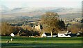
Dalnair House
See Image for a closer look, and for more information about the building. Both pictures were taken from Image; the present picture was taken under slightly better lighting conditions, and is intended to provide more context.
Image: © Lairich Rig
Taken: 11 Oct 2013
0.11 miles
6
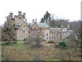
Dalnair House
This building (built around 1884) was formerly used as a nursing home, and is seen here from the footpath and cycle route. Its architects were Clarke & Bell, whose architectural practice included George Bell I and II (father and son), and William Clarke.
A later picture shows the building with more of its surroundings: Image
My thanks to Elinor Combes, who tells me that "in 1972 Dalnair House was purchased by British Steel Corporation as a Management Training College for General Steels Division. The modern additional block was built in 1974/75 to house the college attendees, who had hitherto been accommodated in hotels from Bearsden to Drymen and had to be transported daily to and from Dalnair."
Thanks also to Gray for bringing the following to my attention: Dalnair House is no longer in use as a nursing home: in February of 2006, an application to create 11 flats within the main building of Dalnair House, and to demolish a 1970s extension to that house and then create 15 flats in a new building on the same site, was given approval (with conditions); however, as of May 2011, no such work had taken place, and the building was in poor condition.
Image: © Lairich Rig
Taken: 23 Mar 2005
0.11 miles
9
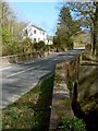
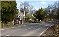
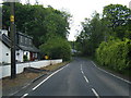
Bridge over the Catter Burn
The photograph was taken from the outskirts of Croftamie. Dalnair Cottage is visible ahead. For a view in the opposite direction over the same bridge, see Image For a view from the bridge, see Image
Image: © Lairich Rig
Taken: 30 Mar 2012
0.22 miles
10
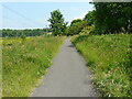
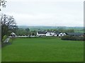
National Cycle Network Route 7
The route follows the line of the former Forth and Clyde Junction Railway.
Image: © Richard Sutcliffe
Taken: 2 Jul 2021
0.24 miles