IMAGES TAKEN NEAR TO
Croftamie, GLASGOW, G63 0EX
Introduction
This page details the photographs taken nearby to G63 0EX by members of the Geograph project.
The Geograph project started in 2005 with the aim of publishing, organising and preserving representative images for every square kilometre of Great Britain, Ireland and the Isle of Man.

There are currently over 7.5m images from over14,400 individuals and you can help contribute to the project by visiting https://www.geograph.org.uk
Image Map
Images are licensed for reuse under creativecommons.org/licenses/by-sa/2.0
Notes
- Clicking on the map will re-center to the selected point.
- The higher the marker number, the further away the image location is from the centre of the postcode.
Image Listing (14 Images Found)
Images are licensed for reuse under creativecommons.org/licenses/by-sa/2.0
Image
Details
Distance
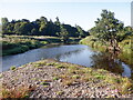
5
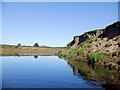
Endrick Water
Bend below Drymen Bridge. The last appreciable current in the river soon quietens down and the water is slow and still all the way to Loch Lomond.
Image: © Richard Webb
Taken: 5 Sep 2023
0.13 miles
6
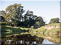
Endrick Water and A811
Below Catter House with the Drymen Show Field on the right.
Image: © Richard Webb
Taken: 5 Sep 2023
0.17 miles
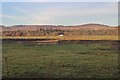
9

Flood plain, Endrick Water
View over The Show Field beside the Endrick Water towards Catter House.
Image: © Richard Webb
Taken: 15 Jun 2010
0.21 miles
10
Endrick Water
Downstream view from near Drymen Bridge.
Image: © Richard Webb
Taken: 5 Sep 2023
0.22 miles