IMAGES TAKEN NEAR TO
Muirpark Way, GLASGOW, G63 0DU
Introduction
This page details the photographs taken nearby to Muirpark Way, G63 0DU by members of the Geograph project.
The Geograph project started in 2005 with the aim of publishing, organising and preserving representative images for every square kilometre of Great Britain, Ireland and the Isle of Man.

There are currently over 7.5m images from over14,400 individuals and you can help contribute to the project by visiting https://www.geograph.org.uk
Image Map
Images are licensed for reuse under creativecommons.org/licenses/by-sa/2.0
Notes
- Clicking on the map will re-center to the selected point.
- The higher the marker number, the further away the image location is from the centre of the postcode.
Image Listing (99 Images Found)
Images are licensed for reuse under creativecommons.org/licenses/by-sa/2.0
Image
Details
Distance
1
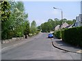
Old Gartmore Road
Leads from Drymen to Gartmore via the Queen Elizabeth Forest Park.
Image: © Stephen Sweeney
Taken: 11 May 2008
0.07 miles
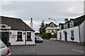
2
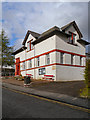
Drymen Village Hall
The village hall is on Old Gartmore Road at the northern end of the village.
Image: © David Dixon
Taken: 17 Apr 2012
0.10 miles
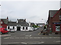
4
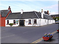
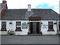
The Clachan Inn, Drymen
In the 1700s Drymen was on the route of the military road from Stirling to Dumbarton. The Clachan Inn, on the northern corner of The Square, dates back to this period and carries signs proclaiming that it was first licensed in 1734, making it Scotland’s oldest ale house.
For more information, visit http://www.undiscoveredscotland.co.uk/drymen/drymen/index.html (Drymen feature page on Undiscovered Scotland) and/or http://www.stirlingonvideo.co.uk/page-details.aspx?PageID=93 (Stirling on Video)
Image: © David Dixon
Taken: 19 Apr 2012
0.11 miles
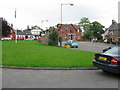
5
Start of the Rob Roy Way, Drymen
Start of the 79 mile route to Pitlochry, past the Clachan Inn and up the Old Gartmore Road on the first leg to Aberfoyle.
Image: © Jim Barton
Taken: 1 Sep 2015
0.11 miles

7
Clachan Inn, Drymen
The road ahead, Old Gartmore Road, is part of the Rob Roy Way. Since the village of Drymen is slightly “off route” for West Highland Way walkers arriving from Milngavie, an option to rejoin the West Highland Way is by following the road ahead rather than retracing one’s steps back down Stirling Road.
Image: © Peter S
Taken: 1 Jun 2014
0.12 miles
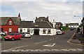
8
The Square, Drymen
Old Gartmore Road to the right of the square was formerly the A811 trunk road prior to it bypassing Drymen.
Image: © G Laird
Taken: 7 Sep 2008
0.12 miles
9
The Square and the Clachan, Drymen
The Old Gartmore Road (used by National Cycle Network route 7) passes the Clachan as it leaves Drymen.
Image: © Richard Webb
Taken: 15 Jun 2010
0.12 miles
10
The Clachan, Drymen
The oldest Inn in Scotland
Image: © william craig
Taken: 6 Jul 2005
0.12 miles