IMAGES TAKEN NEAR TO
Drymen, GLASGOW, G63 0DN
Introduction
This page details the photographs taken nearby to G63 0DN by members of the Geograph project.
The Geograph project started in 2005 with the aim of publishing, organising and preserving representative images for every square kilometre of Great Britain, Ireland and the Isle of Man.

There are currently over 7.5m images from over14,400 individuals and you can help contribute to the project by visiting https://www.geograph.org.uk
Image Map
Images are licensed for reuse under creativecommons.org/licenses/by-sa/2.0
Notes
- Clicking on the map will re-center to the selected point.
- The higher the marker number, the further away the image location is from the centre of the postcode.
Image Listing (39 Images Found)
Images are licensed for reuse under creativecommons.org/licenses/by-sa/2.0
Image
Details
Distance
1
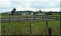
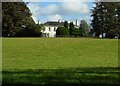
Gaidrew
An extended Gaidrew Farmhouse on the left, Gaidrew Cottage in the centre and The Bungalow on the right. Seen from the route of the former Forth and Clyde Junction Railway line. This is part of National Cycle Network Route 7.
Image: © Richard Sutcliffe
Taken: 4 Aug 2023
0.02 miles
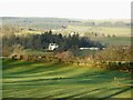
2
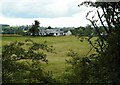
Gaidrew
An extended Gaidrew Farmhouse and associated cottage. Seen from the route of the former Forth and Clyde Junction Railway line. This is part of National Cycle Network Route 7.
Image: © Richard Sutcliffe
Taken: 4 Aug 2023
0.02 miles
3

Gaidrew
This is the westernmost of several buildings at Gaidrew. The picture was taken from the eastern end of Image
Image: © Lairich Rig
Taken: 11 Oct 2013
0.06 miles
4
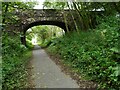
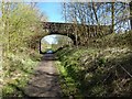
Bridge over the old railway line
The bridge gives access to Gaidrew and associated properties. It crosses the former Forth and Clyde Junction Railway line. This is now part of National Cycle Network Route 7.
Image: © Richard Sutcliffe
Taken: 4 Aug 2023
0.07 miles
5
Bridge over the old railway line
The bridge gives access to Gaidrew and associated properties. It crosses the former Forth and Clyde Junction Railway line. This is now part of National Cycle Network Route 7.
Image: © Richard Sutcliffe
Taken: 4 Aug 2023
0.07 miles
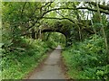
6
Cycle path near Gaidrew
The cycle route / footpath shown here follows the course of the dismantled Forth and Clyde Junction Railway. The bridge, built to cross the railway line, does not appear on the first-edition OS map (c.1860), but it was present by the time the second-edition map was surveyed in c.1898. It still carries the road that gives vehicular access to Image
See Image for a view in the opposite direction.
Image: © Lairich Rig
Taken: 18 Apr 2014
0.07 miles
7
Gaidrew
Seen from beside the eastern end of the Endrick Viaduct.
Image: © Richard Sutcliffe
Taken: 20 Aug 2023
0.07 miles
8
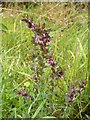
Red Bartsia
(Odontites vernus syn. Odontites verna)
The plant was on the northern side of a path, which is also a cycle route (Image).
In form, the plant is similar to Eyebright and Yellow Rattle, and it is indeed of the same family. All three of those plants are hemiparasites: annuals, rather than longer-lived perennials, they will only grow vigorously if their roots meet those of another plant; by tapping into other roots, they are able to do without developing an extensive root system of their own, and they can devote more of the plant's resources to growing the shoot [on this lifestyle, see, for example, pages 224-225 of "Collins New Generation Guide: Wild Flowers of Britain and Northern Europe" (1987)].
For the other species mentioned above, see Image and Image
[Some books give the name Odontites verna, rather than O. vernus, but, at the time of writing (2014), the latter is the current name (by Article 62.4 of the Melbourne Code).]
Image: © Lairich Rig
Taken: 25 Aug 2014
0.09 miles
9
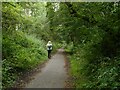
Old railway line path
Following the route of the former Forth and Clyde Junction Railway line. This is now part of National Cycle Network Route 7.
Image: © Richard Sutcliffe
Taken: 4 Aug 2023
0.09 miles
10
Gaidrew
Zoomed view from beside the A809.
Image: © Richard Sutcliffe
Taken: 3 Jan 2025
0.11 miles