IMAGES TAKEN NEAR TO
Ellangowan Court, GLASGOW, G62 8PP
Introduction
This page details the photographs taken nearby to Ellangowan Court, G62 8PP by members of the Geograph project.
The Geograph project started in 2005 with the aim of publishing, organising and preserving representative images for every square kilometre of Great Britain, Ireland and the Isle of Man.

There are currently over 7.5m images from over14,400 individuals and you can help contribute to the project by visiting https://www.geograph.org.uk
Image Map
Images are licensed for reuse under creativecommons.org/licenses/by-sa/2.0
Notes
- Clicking on the map will re-center to the selected point.
- The higher the marker number, the further away the image location is from the centre of the postcode.
Image Listing (591 Images Found)
Images are licensed for reuse under creativecommons.org/licenses/by-sa/2.0
Image
Details
Distance
1
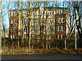
Looking through the trees
Flats at Ellangowan Court seen through leafless trees from the Milngavie Community Library & Education Centre's car park.
Image: © Richard Sutcliffe
Taken: 8 Feb 2022
0.03 miles
2
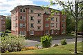
Block of flats, Ellangowan Court
Seen from Sinclair Street.
Image: © Richard Sutcliffe
Taken: 13 May 2020
0.03 miles
3
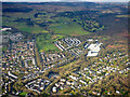
Milngavie from the air
Looking over the north west corner of the town to open countryside and the Kilpatrick Hills.
Image: © Thomas Nugent
Taken: 24 Jan 2020
0.03 miles
4
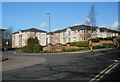
Blocks of flats
On Ellangowan Court, Milngavie.
Image: © Richard Sutcliffe
Taken: 7 Apr 2020
0.04 miles

6

Wee Green Library van
A 2022 Maxus electric van belonging to East Dunbartonshire Leisure & Culture, parked outside Milngavie Community Library & Education Centre.
Image: © Richard Sutcliffe
Taken: 16 Jul 2024
0.05 miles
7
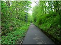
Milngavie, old railway track
Through this cutting ran the spur from the main line of the Milngavie and Glasgow Junction Railway which served the Ellangowan paper mill from 1890 onwards.
This is now the beginnings of the West Highland Way long distance path to Fort William 95 miles away.
Image: © Robert Murray
Taken: 7 May 2011
0.05 miles
8
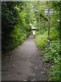
West Highland Way path
This section of the route follows a former railway cutting. A railway line spur ran here connecting the former Ellangowan Paper Mills to Milngavie Station and onwards towards Glasgow.
Image: © Richard Sutcliffe
Taken: 8 Jul 2020
0.05 miles
9
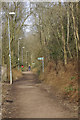
West Highland Way, Milngavie
The West Highland Way - Scotland's first official long-distance route - was completed in 1980 and runs for 95 miles from here at Milngavie to Fort William. At this location, however, it is more likely to attract local dog walkers than mountain trekkers.
Image: © Stephen McKay
Taken: 19 Mar 2008
0.05 miles
10
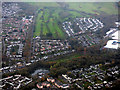
Milngavie from the air
Looking across Clober Road to Clober Golf Club.
Image: © Thomas Nugent
Taken: 3 Nov 2017
0.05 miles