IMAGES TAKEN NEAR TO
Allander Road, GLASGOW, G62 8PN
Introduction
This page details the photographs taken nearby to Allander Road, G62 8PN by members of the Geograph project.
The Geograph project started in 2005 with the aim of publishing, organising and preserving representative images for every square kilometre of Great Britain, Ireland and the Isle of Man.

There are currently over 7.5m images from over14,400 individuals and you can help contribute to the project by visiting https://www.geograph.org.uk
Image Map
Images are licensed for reuse under creativecommons.org/licenses/by-sa/2.0
Notes
- Clicking on the map will re-center to the selected point.
- The higher the marker number, the further away the image location is from the centre of the postcode.
Image Listing (692 Images Found)
Images are licensed for reuse under creativecommons.org/licenses/by-sa/2.0
Image
Details
Distance
2
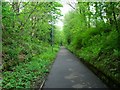
Milngavie, old railway track
Through this cutting ran the spur from the main line of the Milngavie and Glasgow Junction Railway which served the Ellangowan paper mill from 1890 onwards.
This is now the beginnings of the West Highland Way long distance path to Fort William 95 miles away.
Image: © Robert Murray
Taken: 7 May 2011
0.03 miles
3
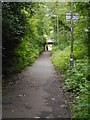
West Highland Way path
This section of the route follows a former railway cutting. A railway line spur ran here connecting the former Ellangowan Paper Mills to Milngavie Station and onwards towards Glasgow.
Image: © Richard Sutcliffe
Taken: 8 Jul 2020
0.03 miles
4
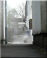
A very dusty job
A man using a hand-held power saw to cut through some concrete is creating a lot of dust.
Image: © Richard Sutcliffe
Taken: 5 May 2021
0.04 miles
5
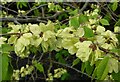
Wych Elm
The developing seeds of wych elm, Ulmus glabra. The tree was growing beside the Allander Water.
Image: © Richard Sutcliffe
Taken: 5 May 2021
0.05 miles
6
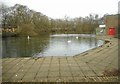
Pond beside Milngavie Library
The pond is in fact a dam for the former Ellangowan paper mill, which used to be just to the south of here.
There is a small fountain bubbling up towards the southern end of the pond. A small floating artificial island is in the middle. This was installed especially in late March for the pair of mute swans to nest on. It replaced a previous one which was deteriorating and was no longer suitable. Also on the water are some tufted ducks, and there are several mallard beside the water's edge.
Image: © Richard Sutcliffe
Taken: 2 Apr 2018
0.05 miles
7

Ellangowan Mills Branch
Former railway now used by the West Highland Way as it leaves Milngavie.
Image: © Richard Webb
Taken: 17 Aug 2016
0.05 miles
8
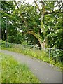
Path beside the Allander
The Allander Water is just the other side of the trees.
Image: © Richard Sutcliffe
Taken: 8 Jul 2020
0.05 miles
9

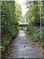
Bridge over the West Highland Way
The bridge carries Allander Road over the long distance path. This section of the route follows a former railway cutting. A railway line spur ran here connecting the former Ellangowan Paper Mills to Milngavie Station and onwards towards Glasgow.
Image: © Richard Sutcliffe
Taken: 18 Feb 2020
0.05 miles
10
West Highland Way near Milngavie
Looking South back towards the start of the path.
Image: © Dave Kelly
Taken: 3 Oct 2014
0.05 miles