IMAGES TAKEN NEAR TO
Highland Road, GLASGOW, G62 8NY
Introduction
This page details the photographs taken nearby to Highland Road, G62 8NY by members of the Geograph project.
The Geograph project started in 2005 with the aim of publishing, organising and preserving representative images for every square kilometre of Great Britain, Ireland and the Isle of Man.

There are currently over 7.5m images from over14,400 individuals and you can help contribute to the project by visiting https://www.geograph.org.uk
Image Map
Images are licensed for reuse under creativecommons.org/licenses/by-sa/2.0
Notes
- Clicking on the map will re-center to the selected point.
- The higher the marker number, the further away the image location is from the centre of the postcode.
Image Listing (655 Images Found)
Images are licensed for reuse under creativecommons.org/licenses/by-sa/2.0
Image
Details
Distance
1

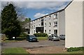
Barloch Avenue
A cul-de-sac off Mugdock Road. A footpath from this point leads up to Cairns Drive.
Image: © Richard Sutcliffe
Taken: 7 Apr 2020
0.02 miles
2

Barloch Avenue
Looking up Barloch Avenue from Mugdock Road. The concrete gate pier has not been used for a long time.
Image: © Richard Sutcliffe
Taken: 1 Feb 2023
0.03 miles

4
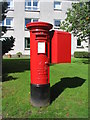
Edward VIII postbox, Sinclair Street
Edward VIII was monarch from 20 January 1936 until his abdication on 11 December 1936. Consequently, post-boxes bearing the E VIII R monogram are comparatively rare.
Image: © E Gammie
Taken: 24 Aug 2018
0.04 miles
5

Edward VIII postbox, Sinclair Street, Milngavie, G62
Image: © Mike Quinn
Taken: 21 Oct 2010
0.04 miles
6
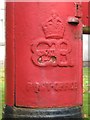
Edward VIII postbox, Sinclair Street, Milngavie, G62 - royal cipher
See Image
Image: © Mike Quinn
Taken: 21 Oct 2010
0.04 miles
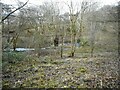
7

Skunk Cabbage and the Tannoch Burn
Large numbers of the spectacular Skunk Cabbage (Lysichiton americanus) thriving beside the Tannoch Burn at Barloch Moor. Most of these plants were subsequently removed in an attempt to eradicate this alien plant from the area.
Image: © Richard Sutcliffe
Taken: 10 Apr 2010
0.04 miles
8
Barloch Moor
The Tannoch Burn runs through the small park off Mugdock Road. Seen from beside Barloch Avenue.
Image: © Richard Sutcliffe
Taken: 1 Feb 2023
0.04 miles
9
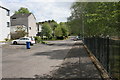
Sinclair Street
Looking towards Mugdock Road.
Image: © Richard Sutcliffe
Taken: 13 May 2020
0.04 miles