IMAGES TAKEN NEAR TO
Milngavie, GLASGOW, G62 8EN
Introduction
This page details the photographs taken nearby to G62 8EN by members of the Geograph project.
The Geograph project started in 2005 with the aim of publishing, organising and preserving representative images for every square kilometre of Great Britain, Ireland and the Isle of Man.

There are currently over 7.5m images from over14,400 individuals and you can help contribute to the project by visiting https://www.geograph.org.uk
Image Map
Images are licensed for reuse under creativecommons.org/licenses/by-sa/2.0
Notes
- Clicking on the map will re-center to the selected point.
- The higher the marker number, the further away the image location is from the centre of the postcode.
Image Listing (67 Images Found)
Images are licensed for reuse under creativecommons.org/licenses/by-sa/2.0
Image
Details
Distance
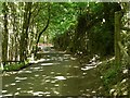
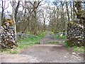
1

The Khyber Pass
A steep section of Broadmeadow Road cuts through rocky outcrops along its route.
According to the Mugdock Country Park Facebook page: "Originally Craigallian Road ran past the front of Craigallian House and the owners of the estate decided to have it re-routed to give them privacy. The pass through the rocky crag was constructed at the same time as the Khyber Pass Railway Line, on the border of Pakistan, and locals jokingly dubbed the work on Craigallian Estate the "Khyber Pass". The name has stuck to this day!"
Image: © Richard Sutcliffe
Taken: 18 Jun 2021
0.01 miles
2
Horse jump
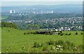
A horse jump made out of tyres close to Mugdock Country Park's Khyber Car Park. Glasgow is in a slight haze beyond.
Image: © Richard Sutcliffe
Taken: 18 Jun 2021
0.05 miles
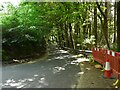
3
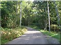
Road at the edge of Mugdock Country Park
Around this bend it becomes very steep, as you can tell if you can make out the house behind the trees in the centre of the image.
Image: © Stephen Sweeney
Taken: 16 Sep 2010
0.06 miles
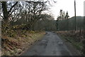
4
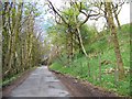
Unclassified road approaching Mugdock Country Park
Image: © Elliott Simpson
Taken: 25 Apr 2015
0.06 miles
5
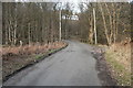
Broadmeadow Road
Looking up the hill. Kyber Cottage can be seen through the trees.
Image: © Richard Sutcliffe
Taken: 14 Mar 2016
0.07 miles
6
The Khyber Pass
A steep section of Broadmeadow Road cuts through rocky outcrops along its route.
According to the Mugdock Country Park Facebook page: "Originally Craigallian Road ran past the front of Craigallian House and the owners of the estate decided to have it re-routed to give them privacy. The pass through the rocky crag was constructed at the same time as the Khyber Pass Railway Line, on the border of Pakistan, and locals jokingly dubbed the work on Craigallian Estate the "Khyber Pass". The name has stuck to this day!"
Image: © Richard Sutcliffe
Taken: 18 Jun 2021
0.07 miles
7
The Khyber Pass
A steep section of Broadmeadow Road cuts through rocky outcrops along its route.
According to the Mugdock Country Park Facebook page: "Originally Craigallian Road ran past the front of Craigallian House and the owners of the estate decided to have it re-routed to give them privacy. The pass through the rocky crag was constructed at the same time as the Khyber Pass Railway Line, on the border of Pakistan, and locals jokingly dubbed the work on Craigallian Estate the "Khyber Pass". The name has stuck to this day!"
Image: © Richard Sutcliffe
Taken: 18 Jun 2021
0.07 miles
8
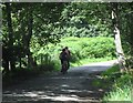
Cyclists on the way up the Kyber Pass
Image: © David Robertson
Taken: 8 Aug 2010
0.10 miles
9
Broadmeadow Road
Looking down the hill. Woodend Lodge can just be seen through the trees.
Image: © Richard Sutcliffe
Taken: 14 Mar 2016
0.12 miles
10
West Highland Way near Craigallian Bridge
Image: © Elliott Simpson
Taken: 25 Apr 2015
0.15 miles