IMAGES TAKEN NEAR TO
Castle Mains Road, GLASGOW, G62 7QN
Introduction
This page details the photographs taken nearby to Castle Mains Road, G62 7QN by members of the Geograph project.
The Geograph project started in 2005 with the aim of publishing, organising and preserving representative images for every square kilometre of Great Britain, Ireland and the Isle of Man.

There are currently over 7.5m images from over14,400 individuals and you can help contribute to the project by visiting https://www.geograph.org.uk
Image Map
Images are licensed for reuse under creativecommons.org/licenses/by-sa/2.0
Notes
- Clicking on the map will re-center to the selected point.
- The higher the marker number, the further away the image location is from the centre of the postcode.
Image Listing (90 Images Found)
Images are licensed for reuse under creativecommons.org/licenses/by-sa/2.0
Image
Details
Distance
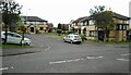
1
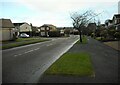
Castle Mains Road
Looking from the junction with Cauldstream Place.
Image: © Richard Sutcliffe
Taken: 6 Feb 2022
0.02 miles
2
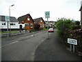
Muirlees Crescent
Off Castle Mains Road.
Image: © Richard Sutcliffe
Taken: 8 May 2022
0.03 miles
3
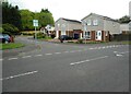
Cairnlee Road
Junction with Castle Mains Road.
Image: © Richard Sutcliffe
Taken: 8 May 2022
0.06 miles
4
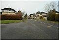
Castle Mains Road
Looking from the junction with Cauldstream Place.
Image: © Richard Sutcliffe
Taken: 6 Feb 2022
0.06 miles
5
Houses on Castle Mains Road
34-60 Even numbers.
Image: © Richard Sutcliffe
Taken: 8 May 2022
0.08 miles
6
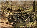
The Craigdhu Burn
Lots of dead wood is lying across the burn, where it runs through a narrow strip of woodland at this point.
Image: © Richard Sutcliffe
Taken: 12 Apr 2021
0.11 miles
7
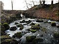
The Craigdhu Burn
Looking downstream from where the burn comes through a concrete pipe. Compare this view with one when the water level was lower Image
Image: © Richard Sutcliffe
Taken: 6 Feb 2022
0.11 miles
8
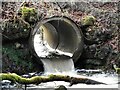
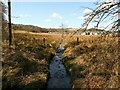
Piped burn
The Craigdhu Burn flows through a concrete pipe, above which is a footpath Image
Image: © Richard Sutcliffe
Taken: 6 Feb 2022
0.11 miles
9
The Craigdhu Burn
The burn flows through a wide pipe here, which allows a rough footpath to cross above.
Image: © Richard Sutcliffe
Taken: 6 Feb 2022
0.11 miles
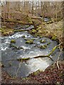
10
The Craigdhu Burn
Looking towards the Mains Estate. The burn has clearly been canalised at some time in the past, as it runs dead straight from here for about 400 metres.
Image: © Richard Sutcliffe
Taken: 12 Apr 2021
0.11 miles