IMAGES TAKEN NEAR TO
Prestonfield, GLASGOW, G62 7PZ
Introduction
This page details the photographs taken nearby to Prestonfield, G62 7PZ by members of the Geograph project.
The Geograph project started in 2005 with the aim of publishing, organising and preserving representative images for every square kilometre of Great Britain, Ireland and the Isle of Man.

There are currently over 7.5m images from over14,400 individuals and you can help contribute to the project by visiting https://www.geograph.org.uk
Image Map
Images are licensed for reuse under creativecommons.org/licenses/by-sa/2.0
Notes
- Clicking on the map will re-center to the selected point.
- The higher the marker number, the further away the image location is from the centre of the postcode.
Image Listing (110 Images Found)
Images are licensed for reuse under creativecommons.org/licenses/by-sa/2.0
Image
Details
Distance
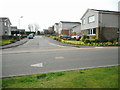
1
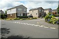
Houses on Prestonfield
Prestonfield consists of several side streets off an outer, roughly circular, road. As it is not a through route, it is a nice quiet residential area.
Image: © Richard Sutcliffe
Taken: 30 Jun 2020
0.02 miles
2
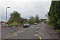
Prestonfield from outside Craigdhu Primary School
Looking west along the southern edge of the Prestonfield estate.
Image: © Richard Dorrell
Taken: 6 Oct 2019
0.03 miles
3
Wheelie bins, Prestonfield
In East Dunbartonshire green bins are for garden waste and the grey/black bins are for non-recyclable materials. Paper, glass, cans etc are collected alternative weeks in other bins.
Prestonfield consists of several side streets off an outer, roughly circular, road. As it is not a through route, it is a nice quiet residential area.
Image: © Richard Sutcliffe
Taken: 30 Jun 2020
0.04 miles
4
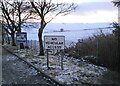
No Vehicular Access
At the entrance to Craigdhu Primary School. The fields behind are covered in overnight snow.
Image: © Richard Sutcliffe
Taken: 7 Jan 2022
0.05 miles
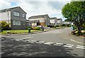
5
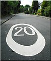
20 MPH limit
Prestonfield consists of several side streets off an outer, roughly circular, road. As it is not a through route, it is a nice quiet residential area. The speed limit applies to all of Prestonfield.
Image: © Richard Sutcliffe
Taken: 30 Jun 2020
0.05 miles
6
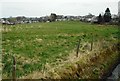
Field behind the fire station
Looking towards the backs of houses on Drumcarn Drive, seen from beside the Craigdhu Burn.
Image: © Richard Sutcliffe
Taken: 14 Apr 2020
0.06 miles
7
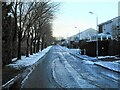
Prestonfield, Milngavie
After snow the previous night.
Image: © Richard Sutcliffe
Taken: 7 Jan 2022
0.06 miles
8
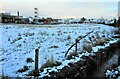
Field behind the fire station
Seen from beside the Craigdhu Burn. It had snowed overnight.
Image: © Richard Sutcliffe
Taken: 7 Jan 2022
0.06 miles
10
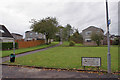
Prestonfield, Milngavie
Prestonfield is an estate, not a single road. The estate is comprised of a loop of road spawning a number of short residential cul-de-sacs. This image is of a pedestrian access through the middle of the estate, viewed from the western end of South Mains Road.
Image: © Richard Dorrell
Taken: 6 Oct 2019
0.08 miles