IMAGES TAKEN NEAR TO
Clober Road, GLASGOW, G62 7LS
Introduction
This page details the photographs taken nearby to Clober Road, G62 7LS by members of the Geograph project.
The Geograph project started in 2005 with the aim of publishing, organising and preserving representative images for every square kilometre of Great Britain, Ireland and the Isle of Man.

There are currently over 7.5m images from over14,400 individuals and you can help contribute to the project by visiting https://www.geograph.org.uk
Image Map
Images are licensed for reuse under creativecommons.org/licenses/by-sa/2.0
Notes
- Clicking on the map will re-center to the selected point.
- The higher the marker number, the further away the image location is from the centre of the postcode.
Image Listing (159 Images Found)
Images are licensed for reuse under creativecommons.org/licenses/by-sa/2.0
Image
Details
Distance
1
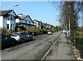
Clober Road
The houses overlook Cloberfield Open Space and the Allander Water.
Image: © Richard Sutcliffe
Taken: 23 Mar 2022
0.01 miles
2

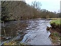
The Allander Water
Looking from the footpath on the eastern bank towards houses on Clober Road. The river level is high, following heavy rain brought by Storm Dennis. The tree trunk probably came downstream due to a different flood. It seems to be stuck solid.
Image: © Richard Sutcliffe
Taken: 18 Feb 2020
0.03 miles
3
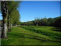
Cloberfield Open Space
This area is situated between Clober Road (on the left) and the Allander Water (beside the woods). A drainage ditch runs parallel to the road.
Image: © Richard Sutcliffe
Taken: 6 May 2020
0.03 miles
4
Allander Water
The river level is high after very heavy rainfall a couple of days earlier.
Image: © Richard Sutcliffe
Taken: 31 Dec 2022
0.04 miles
5
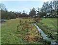
Cloberfield Open Space
Following heavy rain a couple of days earlier, the Allander Water (left) is high Image The normally slow-flowing drainage ditch on the right is flowing quickly.
Image: © Richard Sutcliffe
Taken: 31 Dec 2022
0.04 miles
6
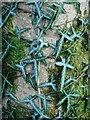
Moss and ivy
A distinctive form of ivy (probably a garden escape) on a tree trunk beside the Allander Water.
Image: © Richard Sutcliffe
Taken: 16 Jan 2023
0.04 miles
7
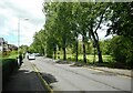
Clober Road
Beyond the trees on the right is Cloberfield Open Space, bounded by the Allander Water.
Image: © Richard Sutcliffe
Taken: 27 May 2022
0.04 miles
8
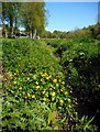
Marsh Marigolds (Caltha palustris)
Growing at the side of a drainage ditch in Allander Park and Cloberfield Open Space.
Image: © Richard Sutcliffe
Taken: 6 May 2020
0.05 miles
9
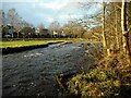
Allander Water
Plenty of water flowing down the Allander Water where it passes the Cloberfield Open Space. The houses in the distance are on Clober Road.
Image: © Richard Sutcliffe
Taken: 8 Feb 2022
0.05 miles
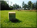
10
Home: Lily Nesbit
One of a series of six way markers by Alex Allan titled ‘Home’. This one is located in Cloberfield Open Space.
lily nesbit
Clober
laundry worker
The West of Scotland Laundry was situated about 200 metres to the south of here, on Clober Road.
See Image for a closer view.
Image: © Richard Sutcliffe
Taken: 12 Aug 2020
0.05 miles