IMAGES TAKEN NEAR TO
Cloberfield Gardens, GLASGOW, G62 7LH
Introduction
This page details the photographs taken nearby to Cloberfield Gardens, G62 7LH by members of the Geograph project.
The Geograph project started in 2005 with the aim of publishing, organising and preserving representative images for every square kilometre of Great Britain, Ireland and the Isle of Man.

There are currently over 7.5m images from over14,400 individuals and you can help contribute to the project by visiting https://www.geograph.org.uk
Image Map
Images are licensed for reuse under creativecommons.org/licenses/by-sa/2.0
Notes
- Clicking on the map will re-center to the selected point.
- The higher the marker number, the further away the image location is from the centre of the postcode.
Image Listing (106 Images Found)
Images are licensed for reuse under creativecommons.org/licenses/by-sa/2.0
Image
Details
Distance
1
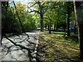
Clober Road
The road at this point is divided by a strip of woodland, so that on each side of the trees the road is one way traffic.
Image: © Richard Sutcliffe
Taken: 6 May 2020
0.04 miles
2
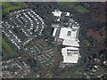
Cloberfield Road factories from the air
Tucked away in a suburb of Milngavie.
Image: © Thomas Nugent
Taken: 8 Nov 2016
0.06 miles
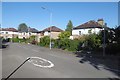
3
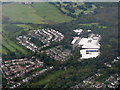
Cloberfield, Milngavie
An industrial estate and housing estate.
Image: © M J Richardson
Taken: 3 Oct 2015
0.06 miles
4
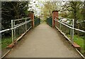
Bridge over the Allander Water
Connecting Allander Park to Clober Open Space.
Image: © Richard Sutcliffe
Taken: 27 Apr 2022
0.08 miles
5
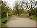
Allander Park
The leaves are just appearing on some of the trees in the park. The litter bin on the right appears to have been set on fire recently.
Image: © Richard Sutcliffe
Taken: 27 Apr 2022
0.09 miles
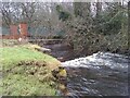
7
Footbridge over the Allander Water
Image: © Richard Sutcliffe
Taken: 18 Feb 2020
0.09 miles
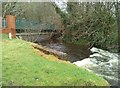
8
Footbridge over the Allander Water
Beside Cloberfield Open Space. There is a small weir immediately downstream of the bridge.
Image: © Richard Sutcliffe
Taken: 31 Dec 2022
0.09 miles
9
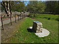
Cloberfield Open Space
This is the northern end of the area. For a view in the opposite direction, see Image The structure visible in both pictures had a plaque on it, with the words "Allander Park & Cloberfield Open Space"; this open space is considered a part of Allander Park, which was designated a Centenary Field in 2014, commemorating those who died in the First World War.
The Allander Water is ahead, behind the railings on the right. See a view south from there: Image As the 1:25000 map shows, there is, between the river and the photographer's position, a much narrower water channel, visible in the present picture.
Image: © Lairich Rig
Taken: 9 May 2016
0.09 miles
10
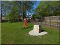
Cloberfield Open Space
This is the northern end of the area. For a view south from there, see Image Houses on Clober Road are visible just ahead.
For a view in the opposite direction, and for another view of object in the foreground, see Image
Image: © Lairich Rig
Taken: 9 May 2016
0.09 miles