IMAGES TAKEN NEAR TO
Galbraith Drive, GLASGOW, G62 6LZ
Introduction
This page details the photographs taken nearby to Galbraith Drive, G62 6LZ by members of the Geograph project.
The Geograph project started in 2005 with the aim of publishing, organising and preserving representative images for every square kilometre of Great Britain, Ireland and the Isle of Man.

There are currently over 7.5m images from over14,400 individuals and you can help contribute to the project by visiting https://www.geograph.org.uk
Image Map
Images are licensed for reuse under creativecommons.org/licenses/by-sa/2.0
Notes
- Clicking on the map will re-center to the selected point.
- The higher the marker number, the further away the image location is from the centre of the postcode.
Image Listing (113 Images Found)
Images are licensed for reuse under creativecommons.org/licenses/by-sa/2.0
Image
Details
Distance
1
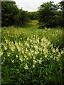
Meadowsweet, Craigdhu Wedge
Large patches of meadowsweet, Filipendula ulmaria, are present within the Craigdhu Wedge, which is recognised as a Local Nature Conservation Site by East Dunbartonshire Council.
Image: © Richard Sutcliffe
Taken: 30 Jun 2020
0.03 miles
2
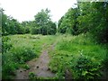
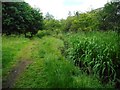
Path beside the Craigdhu Burn
The 'official' surfaced path through the Craigdhu Wedge is about 40 metres to the west. This is a muddy 'desire line' path which follows the burn. The burn itself is hidden by the vegetation growing beside it on the right.
Image: © Richard Sutcliffe
Taken: 30 Jun 2020
0.04 miles
3
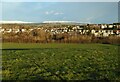
Milngavie and the Craigdhu Wedge
The houses are in Milngavie. The trees and scrub in the middle mark the Craigdhu Wedge, which follows the Craigdhu Burn. The burn is the boundary between Milngavie and Bearsden at this point.
Image: © Richard Sutcliffe
Taken: 30 Dec 2020
0.04 miles
4
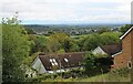
View over Milngavie
Looking from Moorfoot Way over trees beside Stockiemuir Road towards part of Milngavie. South Mains Farm is on the left.
Image: © Richard Sutcliffe
Taken: 18 Sep 2023
0.04 miles
5
Path beside the Craigdhu Burn
The 'official' surfaced path through the Craigdhu Wedge is about 40 metres to the west. This is a muddy 'desire line' path which follows the burn. The plants beside the burn on the right are yellow flag (iris).
Image: © Richard Sutcliffe
Taken: 30 Jun 2020
0.06 miles
6
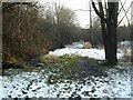
Muddy path beside the Craigdhu Burn
This path is a 'desire line' running beside the burn, through the Craigdhu Wedge. It is often muddy, and the overnight snow hasn't helped. Drips from melting snow from the canopy of a large tree have melted the snow beneath it and made the path a bit worse here.
Image: © Richard Sutcliffe
Taken: 7 Jan 2022
0.07 miles
7
What a difference the sun makes
On a cold December afternoon, the low sun has melted the frost on the northern side of the Craigdhu Wedge, but in the southern side, which has remained in shadow, the ground is still frozen. The walker is on the path that runs through the Wedge.
Image: © Richard Sutcliffe
Taken: 30 Dec 2020
0.08 miles
8
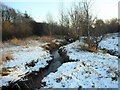
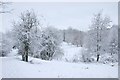
The Craigdhu Burn
It had snowed the previous night.
Image: © Richard Sutcliffe
Taken: 7 Jan 2022
0.08 miles
9
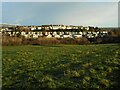
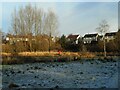
Houses, Milngavie
The houses are on Drumlin Drive and Galbraith Drive in Milngavie. The trees and scrub in the middle mark the Craigdhu Wedge, which follows the Craigdhu Burn. The burn is the boundary between Milngavie and Bearsden at this point.
Image: © Richard Sutcliffe
Taken: 30 Dec 2020
0.08 miles
10
The Craigdhu Wedge
A couple are walking their dog along the path on the left.
Image: © Richard Sutcliffe
Taken: 21 Jan 2018
0.09 miles