IMAGES TAKEN NEAR TO
Breadie Drive, GLASGOW, G62 6LR
Introduction
This page details the photographs taken nearby to Breadie Drive, G62 6LR by members of the Geograph project.
The Geograph project started in 2005 with the aim of publishing, organising and preserving representative images for every square kilometre of Great Britain, Ireland and the Isle of Man.

There are currently over 7.5m images from over14,400 individuals and you can help contribute to the project by visiting https://www.geograph.org.uk
Image Map
Images are licensed for reuse under creativecommons.org/licenses/by-sa/2.0
Notes
- Clicking on the map will re-center to the selected point.
- The higher the marker number, the further away the image location is from the centre of the postcode.
Image Listing (116 Images Found)
Images are licensed for reuse under creativecommons.org/licenses/by-sa/2.0
Image
Details
Distance
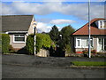
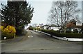
1
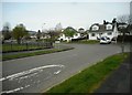
Junction of Breadie Drive and South Mains Road
Image: © Richard Sutcliffe
Taken: 14 Apr 2020
0.03 miles
2
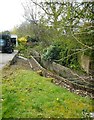
Craigdhu Burn
The burn runs along a narrow concrete-lined trough.
Image: © Richard Sutcliffe
Taken: 14 Apr 2020
0.05 miles
3
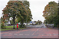
South Mains Road from Prestonfield
With leaves tinted by autumn, and a smart red post box.
Image: © Richard Dorrell
Taken: 6 Oct 2019
0.06 miles
4
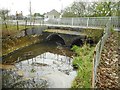
Craigdhu Burn
The burn enters a double culvert to go under Prestonfield.
Image: © Richard Sutcliffe
Taken: 14 Apr 2020
0.06 miles
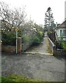
5
Footpath off Keystone Quadrant, Milngavie
Leading to South Mains Road.
Image: © Richard Vince
Taken: 12 Sep 2022
0.07 miles
6
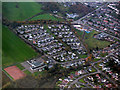
Prestonfield from the air
A suburb on the outskirts of Milngavie.
Image: © Thomas Nugent
Taken: 3 Nov 2017
0.07 miles
7
Footpath off South Mains Road
Leading to Keystone Quadrant.
Image: © Richard Sutcliffe
Taken: 14 Apr 2020
0.07 miles
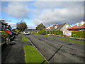
9
Crossburn Avenue, Milngavie
Seen from South Mains Road.
Image: © Richard Sutcliffe
Taken: 14 Apr 2020
0.08 miles
10
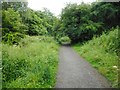
Path through the Craigdhu Wedge
This well-surfaced path runs for just under a mile from Milngavie Road to Prestonfields following the route of the Craigdhu Burn through the Craigdhu Wedge. It also connects with paths which lead to Stockiemuir Avenue and Galbraith Drive.
The Craigdhu Wedge is recognised as a Local Nature Conservation Site by East Dunbartonshire Council.
Image: © Richard Sutcliffe
Taken: 30 Jun 2020
0.09 miles