IMAGES TAKEN NEAR TO
Oswald Walk, GLASGOW, G62 6AY
Introduction
This page details the photographs taken nearby to Oswald Walk, G62 6AY by members of the Geograph project.
The Geograph project started in 2005 with the aim of publishing, organising and preserving representative images for every square kilometre of Great Britain, Ireland and the Isle of Man.

There are currently over 7.5m images from over14,400 individuals and you can help contribute to the project by visiting https://www.geograph.org.uk
Image Map
Images are licensed for reuse under creativecommons.org/licenses/by-sa/2.0
Notes
- Clicking on the map will re-center to the selected point.
- The higher the marker number, the further away the image location is from the centre of the postcode.
Image Listing (63 Images Found)
Images are licensed for reuse under creativecommons.org/licenses/by-sa/2.0
Image
Details
Distance
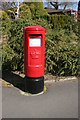
1

Finlay Rise
The pillar box is postbox number G62 688D.
Image: © Richard Sutcliffe
Taken: 21 Apr 2020
0.04 miles
2
Pillar box, Finlay Rise
The pillar box is postbox number G62 688D. It appears to have been repainted recently.
Image: © Richard Sutcliffe
Taken: 21 Apr 2020
0.04 miles

4
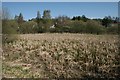
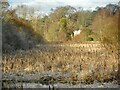
Dougalston Loch
Much of the loch is covered by vegetation, although there is still plenty of open water. This part is particularly clogged with the remains of last year's greater reedmace (Typha latifolia). The loch and part of Dougalston Estate are designated as a Local Nature Conservation Site by East Dunbartonshire Council.
The houses in the background are on Bridgegait and Finlay Rise.
Image: © Richard Sutcliffe
Taken: 21 Apr 2020
0.09 miles
5
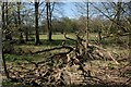
Dead wood
This tree has fallen, and is being left where it fell to provide valuable habitat for wildlife. Dougalston Loch and part of Dougalston Estate are designated as a Local Nature Conservation Site by East Dunbartonshire Council.
Image: © Richard Sutcliffe
Taken: 21 Apr 2020
0.09 miles
6
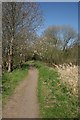
Spring blossom
The path follows the edge of Dougalston Loch (to the right, out of picture).
Image: © Richard Sutcliffe
Taken: 21 Apr 2020
0.10 miles
7
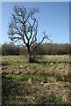
Lone tree
This tree in the rough grassland close to Dougalston Loch is in poor condition. Most of the branches on the right are dead or dying.
Image: © Richard Sutcliffe
Taken: 21 Apr 2020
0.11 miles
8
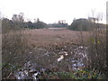
Dougalston Loch
The much silted-up southeastern end of Dougalston Loch, much of which is full of greater reedmace (Typha latifolia). The Craigmaddie Burn is in the immediate foreground. Seen on a cold and frosty January morning. The loch and part of Dougalston Estate are designated as a Local Nature Conservation Site by East Dunbartonshire Council.
Image: © Richard Sutcliffe
Taken: 2 Jan 2023
0.11 miles
9
Dougalston Loch
It is difficult to see the water with the number of reeds growing in the water.
Image: © G Laird
Taken: 26 Dec 2013
0.11 miles
10
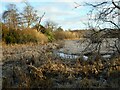
The Craigmaddie Burn
The burn threads its way through a very much silted-up southeastern end of Dougalston Loch before cascading down a weir Image just out of view to the right. The loch and part of Dougalston Estate are designated as a Local Nature Conservation Site by East Dunbartonshire Council.
Image: © Richard Sutcliffe
Taken: 2 Jan 2023
0.11 miles