IMAGES TAKEN NEAR TO
Skye Gardens, GLASGOW, G61 4ED
Introduction
This page details the photographs taken nearby to Skye Gardens, G61 4ED by members of the Geograph project.
The Geograph project started in 2005 with the aim of publishing, organising and preserving representative images for every square kilometre of Great Britain, Ireland and the Isle of Man.

There are currently over 7.5m images from over14,400 individuals and you can help contribute to the project by visiting https://www.geograph.org.uk
Image Map
Images are licensed for reuse under creativecommons.org/licenses/by-sa/2.0
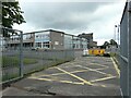
Notes
- Clicking on the map will re-center to the selected point.
- The higher the marker number, the further away the image location is from the centre of the postcode.
Image Listing (38 Images Found)
Images are licensed for reuse under creativecommons.org/licenses/by-sa/2.0
Image
Details
Distance
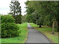
1
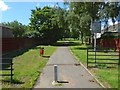
The course of the Antonine Wall
As the sign points out, the open ground beside this path, running west from this point, preserves the line of the Antonine Wall. See Image for a view in the opposite direction from a point 200 metres further along the path.
Image: © Lairich Rig
Taken: 3 Jul 2015
0.04 miles
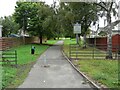
2
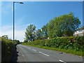
Duntocher Road
The houses beyond the hedge are on Bonnaughton Road, which runs parallel to this one.
Image: © Lairich Rig
Taken: 12 Jun 2015
0.05 miles
3
The course of the Antonine Wall
The path and the open space beside it preserve the line of the Antonine Wall. The picture was taken from a point 200m further along the path shown in Image, but the view is in the opposite direction.
Image: © Lairich Rig
Taken: 3 Jul 2015
0.08 miles
4
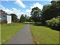
Line of the Antonine Wall
The line of the Antonine Wall is preserved by the open ground running between Antonine Road and Rosslyn Road. It is a Scheduled Monument http://portal.historicenvironment.scot/designation/SM6898.
Image: © Richard Sutcliffe
Taken: 8 Aug 2021
0.08 miles
5
Line of the Antonine Wall
The line of the Antonine Wall is preserved by the open ground running between Rosslyn Road and Antonine Road. It is a Scheduled Monument http://portal.historicenvironment.scot/designation/SM6898.
Image: © Richard Sutcliffe
Taken: 8 Aug 2021
0.09 miles
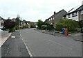
7
Duntocher Road
Behind the hedge on each side is a road that is parallel to this one: Bonnaughton Road on the left (north) and Castlehill Road on the right.
There is a staggered junction about 150 metres ahead.
Image: © Lairich Rig
Taken: 12 Jun 2015
0.10 miles
8
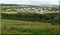
Houses, Bearsden
Seen from the top of Castle Hill.
Image: © Richard Sutcliffe
Taken: 8 Aug 2021
0.11 miles
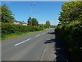
9
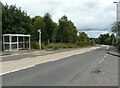
Entering Bearsden
Looking east on the A810, Duntocher Road. Antonine Road leads off to the right.
Image: © Richard Sutcliffe
Taken: 8 Aug 2021
0.12 miles