IMAGES TAKEN NEAR TO
Heather Avenue, GLASGOW, G61 3JB
Introduction
This page details the photographs taken nearby to Heather Avenue, G61 3JB by members of the Geograph project.
The Geograph project started in 2005 with the aim of publishing, organising and preserving representative images for every square kilometre of Great Britain, Ireland and the Isle of Man.

There are currently over 7.5m images from over14,400 individuals and you can help contribute to the project by visiting https://www.geograph.org.uk
Image Map
Images are licensed for reuse under creativecommons.org/licenses/by-sa/2.0
Notes
- Clicking on the map will re-center to the selected point.
- The higher the marker number, the further away the image location is from the centre of the postcode.
Image Listing (46 Images Found)
Images are licensed for reuse under creativecommons.org/licenses/by-sa/2.0
Image
Details
Distance
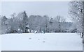
1
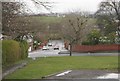
Heather Avenue
Heather Avenue runs east down a slight hill. Bailie Drive in the foreground joins it at the corner. The 'desire line' path on the left runs from Stockiemuir Road.
Image: © Richard Sutcliffe
Taken: 27 Mar 2016
0.04 miles
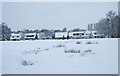
2
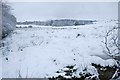
Snowy fields on the edge of Bearsden
Image: © Richard Sutcliffe
Taken: 21 Jan 2018
0.06 miles
3
Junction of Heather Avenue and Bailie Drive
Viewed from Stockiemuir Road. The grassy strip is about 50 metres wide and runs for about 350 metres between Stockiemuir Avenue and Bailie Drive.
Image: © Richard Sutcliffe
Taken: 27 Mar 2016
0.09 miles
4
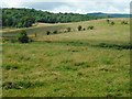
Fields beside Craigdhu Road
Craigdhu Road runs from left to right across the photograph, hidden by the hedges at the edge of the fields. In the distance is Mains Plantation.
Image: © Richard Sutcliffe
Taken: 30 Jun 2020
0.10 miles
5
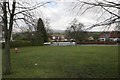
Heather Avenue Playground in the snow
Image: © Richard Sutcliffe
Taken: 21 Jan 2018
0.11 miles
6
Ground beside Heather Avenue in the snow
Image: © Richard Sutcliffe
Taken: 21 Jan 2018
0.12 miles
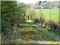
7
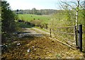
Old road
This is the original route of Craigdhu Road, leading off the present road (B8050). Now it acts as a footpath.
Image: © Richard Sutcliffe
Taken: 21 Apr 2019
0.12 miles
8
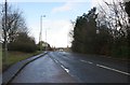
Lay-by, Stockiemuir Road
Looking north along Stockiemuir Road (A809) towards the Baljaffray Roundabout.
Image: © Richard Sutcliffe
Taken: 27 Mar 2016
0.13 miles
9
Footpath beside Craigdhu Road
This is the original route of Craigdhu Road, leading off the present road (B8050). Now it acts as a footpath.
Image: © Richard Sutcliffe
Taken: 21 Apr 2019
0.13 miles
10
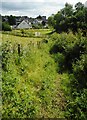
Overgrown footpath
This part of the footpath to Heather Avenue is along a narrow, slightly overgrown corridor between a fence and a hedge. In the middle distance is a metal bridge over an un-named tributary of the Craigdhu Burn. From there you can either cross the bridge and continue straight on to Heather Avenue, or turn left and follow a path which leads to the Craigdhu Wedge.
Image: © Richard Sutcliffe
Taken: 30 Jun 2020
0.14 miles