IMAGES TAKEN NEAR TO
Bennie Place, GLASGOW, G61 3EG
Introduction
This page details the photographs taken nearby to Bennie Place, G61 3EG by members of the Geograph project.
The Geograph project started in 2005 with the aim of publishing, organising and preserving representative images for every square kilometre of Great Britain, Ireland and the Isle of Man.

There are currently over 7.5m images from over14,400 individuals and you can help contribute to the project by visiting https://www.geograph.org.uk
Image Map
Images are licensed for reuse under creativecommons.org/licenses/by-sa/2.0
Notes
- Clicking on the map will re-center to the selected point.
- The higher the marker number, the further away the image location is from the centre of the postcode.
Image Listing (376 Images Found)
Images are licensed for reuse under creativecommons.org/licenses/by-sa/2.0
Image
Details
Distance
1
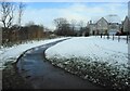
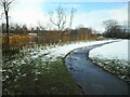
Path to the Allander Leisure Centre
A tightly planted strip of woodland, planted as part of the adjacent housing development is between the footpath to the Allander Leisure Centre and the Craigdhu Burn on the left.
Image: © Richard Sutcliffe
Taken: 24 Feb 2022
0.03 miles
2
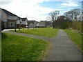
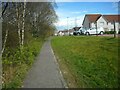
Path from the Allander
The path leads from the Allander Leisure and Day Care Centre (behind the photographer) to Milngavie Road. The houses on the left are on Bennie Place.
Image: © Richard Sutcliffe
Taken: 14 Apr 2023
0.03 miles
3
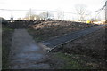
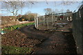
Diverted path
The original path from the Allander Leisure Centre to the A81 went straight on. At this point the path has been diverted to the right, where the building site for the new housing development by Cala Homes encroaches on the original route.
Image: © Richard Sutcliffe
Taken: 2 Jan 2017
0.03 miles
4
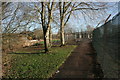
Footpath to the Allander Leisure Centre
The path runs beside the site of the new housing development by Cala Homes. At this point the path has been diverted to the left, where the building site for the new houses encroaches on the original path.
Image: © Richard Sutcliffe
Taken: 2 Jan 2017
0.04 miles
5
Footpath to the Allander Leisure Centre
The path runs beside the site of the new housing development by Cala Homes. At this point the path has been diverted to the left, where the building site for the new houses encroaches on the original path.
Image: © Richard Sutcliffe
Taken: 2 Jan 2017
0.04 miles
6
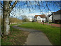
Path to the Allander
The path leads to the Allander Leisure and Day Care Centre from Milngavie Road. The houses are on Bennie Place.
Image: © Richard Sutcliffe
Taken: 14 Apr 2023
0.04 miles
7
Young strip of woodland
A tightly planted strip of woodland, planted as part of the adjacent housing development between the footpath to the Allander Leisure Centre and the Craigdhu Burn.
Image: © Richard Sutcliffe
Taken: 24 Feb 2022
0.04 miles
8
Path to the Allander
The path leads to the Allander Leisure and Day Care Centre (just visible in the distance) from Milngavie Road. The houses are on Bennie Place.
Image: © Richard Sutcliffe
Taken: 14 Apr 2023
0.04 miles
9
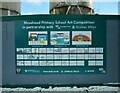
Art of construction
A large display on the hoarding beside the construction site for the new Allander Leisure and Day Care Centre. It shows the results of an art competition run by Mosshead Primary School (the local primary school) in partnership with the construction companies. Congratulations to Freya, George, Reuben and all the other pupils.
Image: © Richard Sutcliffe
Taken: 24 Feb 2022
0.04 miles
10
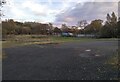
Open space
Looking from just inside the gates Image across the open ground towards the new Allander Leisure Centre and Day Care Centre, currently under construction beyond the trees.
Image: © Richard Sutcliffe
Taken: 2 Nov 2021
0.04 miles