IMAGES TAKEN NEAR TO
Milngavie Road, GLASGOW, G61 3DJ
Introduction
This page details the photographs taken nearby to Milngavie Road, G61 3DJ by members of the Geograph project.
The Geograph project started in 2005 with the aim of publishing, organising and preserving representative images for every square kilometre of Great Britain, Ireland and the Isle of Man.

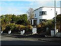
There are currently over 7.5m images from over14,400 individuals and you can help contribute to the project by visiting https://www.geograph.org.uk
Image Map
Images are licensed for reuse under creativecommons.org/licenses/by-sa/2.0
Notes
- Clicking on the map will re-center to the selected point.
- The higher the marker number, the further away the image location is from the centre of the postcode.
Image Listing (148 Images Found)
Images are licensed for reuse under creativecommons.org/licenses/by-sa/2.0
Image
Details
Distance
1
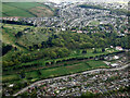
Douglas park Golf Club from the air
The A81 Milngavie Road and the Milngavie branch railway line are in the foreground. New Kilpatrick Cemetery stands on the hill.
Image: © Thomas Nugent
Taken: 5 May 2022
0.05 miles
2
Lower Kilmardinny House
The A81 Milngavie Road and Lower Kilmardinny House.
Image: © Richard Sutcliffe
Taken: 20 Jun 2015
0.07 miles
3
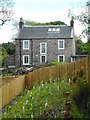
Lower Kilmardinny House
The house, which is clearly called Lower Kilmardinny House, has recently been re-roofed.
According to old maps, this was Kilmardinny Cottage, and the Category B listed Lower Kilmardinny House was (and still is) about 50 metres to the east. However, it is now part of Kilmardinny Estate Self-catering Cottages.
Image: © Richard Sutcliffe
Taken: 12 May 2020
0.07 miles
4
Lower Kilmardinny House
The house beside the A81 is clearly called Lower Kilmardinny House.
According to old maps, this was Kilmardinny Cottage, and the Category B listed Lower Kilmardinny House was (and still is) about 50 metres to the east.
Image: © Richard Sutcliffe
Taken: 12 Jan 2022
0.07 miles
5
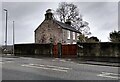
Overdale, 2 Carse View Drive
Category C listed building by J.R.H. MacDonald, 1934.
Image: © Richard Sutcliffe
Taken: 24 Apr 2018
0.08 miles
6
1 Carse View Drive
Category C listed building by J.R.H. MacDonald, 1936.
Image: © Richard Sutcliffe
Taken: 24 Apr 2018
0.08 miles
7

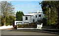
1 and 2 Carse View Drive
By J.R.H. MacDonald of John MacDonald (contractors) Ltd. (Burnside and Kilmardinny) in the International style. Number 1 (on the left) dates from 1936; number 2 (right) dates from 1934. Both are Category C listed http://portal.historicenvironment.scot/designation/LB22136, http://portal.historicenvironment.scot/designation/LB22137.
Image: © Richard Sutcliffe
Taken: 15 Jan 2022
0.08 miles
8

Carse View Drive
Looking down the hill.
Image: © Richard Sutcliffe
Taken: 15 Jan 2022
0.08 miles
9
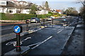
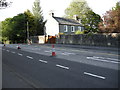
Bears Way, A81
The Bears Way is the two-way cycle lane alongside the A81 in Bearsden and Milngavie. Phase 1 was completed in 2015 and has been very controversial. Although liked by some, there have been many complaints and criticisms, from drivers and cyclists alike.
Image: © Richard Sutcliffe
Taken: 6 Dec 2015
0.09 miles
10
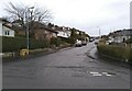
Douglas Park Crescent
A residential street in Bearsden.
Image: © Richard Sutcliffe
Taken: 12 Jan 2022
0.09 miles