IMAGES TAKEN NEAR TO
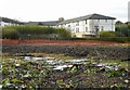
Switchback Road, GLASGOW, G61 1QN
Introduction
This page details the photographs taken nearby to Switchback Road, G61 1QN by members of the Geograph project.
The Geograph project started in 2005 with the aim of publishing, organising and preserving representative images for every square kilometre of Great Britain, Ireland and the Isle of Man.

There are currently over 7.5m images from over14,400 individuals and you can help contribute to the project by visiting https://www.geograph.org.uk
Image Map
Images are licensed for reuse under creativecommons.org/licenses/by-sa/2.0
Notes
- Clicking on the map will re-center to the selected point.
- The higher the marker number, the further away the image location is from the centre of the postcode.
Image Listing (45 Images Found)
Images are licensed for reuse under creativecommons.org/licenses/by-sa/2.0
Image
Details
Distance
1
Canniesburn Care Home
Seen from Switchback Road. This view did not exist until a private house and garage were demolished in March 2017, and the site cleared. A three storey building with 23 two-bedroom retirement flats is due to be constructed here.
Image: © Richard Sutcliffe
Taken: 5 Apr 2017
0.03 miles
2
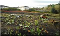
Site of former house on Switchback Road, beside Canniesbuen Toll
This was previously the site of a house and garage, surrounded by a large garden. The buildings were demolished in March 2017, and the site cleared. A three storey building with 23 two-bedroom retirement flats is due to be constructed here.
The Canniesburn Care Home is beyond.
Image: © Richard Sutcliffe
Taken: 5 Apr 2017
0.04 miles
3

Rusty fence and scrub, Canniesburn Toll
Just to the southwest of Canniesburn Toll roundabout.
Image: © Richard Sutcliffe
Taken: 5 Apr 2017
0.04 miles
4
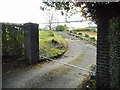
Former driveway to house off Switchback Road
Previously the drive to a private house and garage, surrounded by a large garden. The buildings were demolished in March 2017, and the site cleared. A three storey building with 23 two-bedroom retirement flats is due to be constructed here.
Image: © Richard Sutcliffe
Taken: 5 Apr 2017
0.04 miles
5
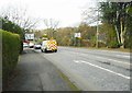
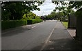
A 739 (Switchback Road) at Canniesburn Toll
Approaching the roundabout at Canniesburn.
Image: © Richard Sutcliffe
Taken: 5 Apr 2017
0.04 miles
6
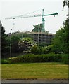
Apartments under construction, Canniesburn
23 apartments on Canniesburn Drive - specifically designed as retirement homes - are under construction. The development will be called Westerly. Seen from across Canniesburn Toll Roundabout.
Image: © Richard Sutcliffe
Taken: 1 Jun 2018
0.06 miles
7
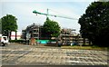
Apartments under construction, Canniesburn
23 apartments on Canniesburn Drive - specifically designed as retirement homes - are under construction. The development will be called Westerly. Seen from across Switchback Road.
Image: © Richard Sutcliffe
Taken: 1 Jun 2018
0.06 miles
8
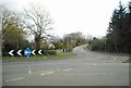
Canniesburn Toll roundabout
Looking towards the A739, Switchback Road.
Image: © Richard Sutcliffe
Taken: 5 Apr 2017
0.06 miles
9
Canniesburn Toll roundabout
The A739 meets the A809 at the roundabout.
Image: © Richard Sutcliffe
Taken: 5 Apr 2017
0.06 miles
10
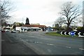
Canniesburn Drive looking south east
The traffic lights are at the junction with the A739 (Switchback Road).
Image: © Richard Sutcliffe
Taken: 9 Jun 2015
0.07 miles