IMAGES TAKEN NEAR TO
Allander Road, GLASGOW, G61 1LT
Introduction
This page details the photographs taken nearby to Allander Road, G61 1LT by members of the Geograph project.
The Geograph project started in 2005 with the aim of publishing, organising and preserving representative images for every square kilometre of Great Britain, Ireland and the Isle of Man.

There are currently over 7.5m images from over14,400 individuals and you can help contribute to the project by visiting https://www.geograph.org.uk
Image Map
Images are licensed for reuse under creativecommons.org/licenses/by-sa/2.0
Notes
- Clicking on the map will re-center to the selected point.
- The higher the marker number, the further away the image location is from the centre of the postcode.
Image Listing (15 Images Found)
Images are licensed for reuse under creativecommons.org/licenses/by-sa/2.0
Image
Details
Distance
1
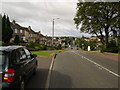
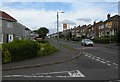
Houses on Canniesburn Road, Bearsden
Image: © Stephen Sweeney
Taken: 2 Aug 2007
0.10 miles
2
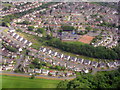
Colquhoun Park Primary School
The arc of houses is on Annan Drive. Seen from the air on the way to Glasgow Airport.
Image: © M J Richardson
Taken: 20 Jun 2015
0.13 miles
3
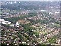
Bearsden from the air
Seen from the northwest on the way into Glasgow Airport.
Image: © M J Richardson
Taken: 20 Jun 2015
0.14 miles
4
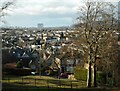
The view from Westfield Drive
Looking towards the prominent tower blocks in Linkswood Crescent in Drumchapel. From this angle it appears there is just one large tower block. In fact there are two Image
Image: © Richard Sutcliffe
Taken: 9 Feb 2023
0.15 miles
5
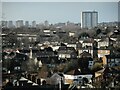
Housing in Westerton and beyond
A mixture of architectural styles with semi-detached houses and terraces in the foreground in Westerton. The tower blocks on the right are in Drumchapel; the more distant ones are in Drumry, beside the A82.
Image: © Richard Sutcliffe
Taken: 9 Feb 2023
0.16 miles
6
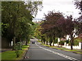
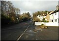
Looking downhill on Pendicle Road
It's no fun getting to the top, but it's worth it!
Image: © Stephen Sweeney
Taken: 2 Aug 2007
0.17 miles
7
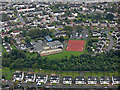
Colquhoun Park Primary School from the air
Some children can be seen on the sports field. Annan Drive is in the foreground.
School web site: http://www.colquhounpark.e-dunbarton.sch.uk/ .
Image: © Thomas Nugent
Taken: 6 Sep 2019
0.18 miles
8
Canniesburn Road
Looking up the hill from Annick Drive.
Image: © Richard Sutcliffe
Taken: 10 Jul 2015
0.20 miles
9
Maxwell Avenue
Looking up the hill from Monreith Avenue.
Image: © Richard Sutcliffe
Taken: 9 Feb 2023
0.22 miles