IMAGES TAKEN NEAR TO
Ascog Road, GLASGOW, G61 1BP
Introduction
This page details the photographs taken nearby to Ascog Road, G61 1BP by members of the Geograph project.
The Geograph project started in 2005 with the aim of publishing, organising and preserving representative images for every square kilometre of Great Britain, Ireland and the Isle of Man.

There are currently over 7.5m images from over14,400 individuals and you can help contribute to the project by visiting https://www.geograph.org.uk
Image Map
Images are licensed for reuse under creativecommons.org/licenses/by-sa/2.0
Notes
- Clicking on the map will re-center to the selected point.
- The higher the marker number, the further away the image location is from the centre of the postcode.
Image Listing (68 Images Found)
Images are licensed for reuse under creativecommons.org/licenses/by-sa/2.0
Image
Details
Distance
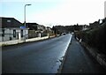
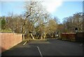
1
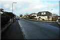
Ravelston Road
Ascog Road is on the right.
Image: © Richard Sutcliffe
Taken: 9 Feb 2023
0.01 miles
3
Cairnhill Woods
The woodland is a mixture of mature trees up to 150 years old and more recent plantings. It is a good site for a variety of wildlife and forms part of an important wildlife corridor through the area. Cairnhill Woods is officially designated a Local Nature Conservation Site (LNCS) by East Dunbartonshire Council.
Image: © Richard Sutcliffe
Taken: 9 Feb 2023
0.05 miles
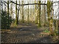
4
Cairnhill Woods
Cairnhill Woods is a narrow strip of woodland, running north to south for about 800 metres. This path links Henderland Road to Ravelston Road, cutting across the woods, which are about 100 metres wide at this point. The woodland is a mixture of mature trees up to 150 years old and more recent plantings. It is a good site for a variety of wildlife and forms part of an important wildlife corridor through the area. Cairnhill Woods is officially designated a Local Nature Conservation Site (LNCS) by East Dunbartonshire Council.
Image: © Richard Sutcliffe
Taken: 9 Feb 2023
0.05 miles
6
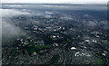
Anniesland and Glasgow from the air
The Forth and Clyde canal at Westerton can be seen at the bottom of the photo.
Image: © Thomas Nugent
Taken: 21 Oct 2013
0.06 miles
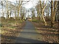
7
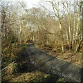
Footpath, Cairnhill Woods
One of the paths which goes through Cairnhill Woods. The woodland is a mixture of mature trees up to 150 years old and more recent plantings. It is a good site for a variety of wildlife and forms part of an important wildlife corridor through the area. Cairnhill Woods is officially designated a Local Nature Conservation Site (LNCS) by East Dunbartonshire Council.
Image: © Richard Sutcliffe
Taken: 9 Feb 2023
0.09 miles
8
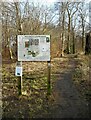
Welcome to Cairnhill Woods
Notice at one of the entrances to Cairnhill Woods - this one off Henderland Road. The woodland is a mixture of mature trees up to 150 years old and more recent plantings. It is a good site for a variety of wildlife and forms part of an important wildlife corridor through the area. Cairnhill Woods is officially designated a Local Nature Conservation Site (LNCS) by East Dunbartonshire Council.
Image: © Richard Sutcliffe
Taken: 9 Feb 2023
0.10 miles
9
Cairnhill Woods
The entrance to Cairnhill Woods off Henderland Road.
Image: © Richard Sutcliffe
Taken: 9 Feb 2023
0.10 miles
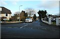
10
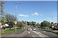
Switchback Road at junction for Lomond Road
Image: © John Firth
Taken: 17 May 2013
0.13 miles