IMAGES TAKEN NEAR TO
Oronsay Square, GLASGOW, G60 5NS
Introduction
This page details the photographs taken nearby to Oronsay Square, G60 5NS by members of the Geograph project.
The Geograph project started in 2005 with the aim of publishing, organising and preserving representative images for every square kilometre of Great Britain, Ireland and the Isle of Man.

There are currently over 7.5m images from over14,400 individuals and you can help contribute to the project by visiting https://www.geograph.org.uk
Image Map
Images are licensed for reuse under creativecommons.org/licenses/by-sa/2.0
Notes
- Clicking on the map will re-center to the selected point.
- The higher the marker number, the further away the image location is from the centre of the postcode.
Image Listing (48 Images Found)
Images are licensed for reuse under creativecommons.org/licenses/by-sa/2.0
Image
Details
Distance
1

Housing on Oronsay Crescent
In Old Kilpatrick.
Image: © Stephen Sweeney
Taken: 16 Jan 2008
0.10 miles
2
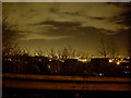
Trees and night sky over Mountblow
The town of Clydebank would be clearly visible, if not for the trees.
Image: © Stephen Sweeney
Taken: 16 Jan 2008
0.11 miles
3
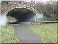
Tunnel in Lusset Glen
Under the railway line.
Image: © Stephen Sweeney
Taken: 20 Jan 2008
0.15 miles
4
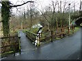
Footbridge in Lusset Glen
Compare Image, a view back towards the footbridge from the other end of the conduit, at the mouth of the tunnel. See also Image
Image: © Lairich Rig
Taken: 10 Mar 2014
0.15 miles
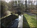
5
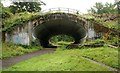
Bridge over the Dalnottar Burn
The railway bridge carries the Glasgow to Dumbarton railway line over the Dalnottar Burn, which is channelled along a spillway to the right of the path.
Image: © Richard Sutcliffe
Taken: 29 Jul 2018
0.15 miles
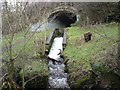
6
Conduit for the Lusset Burn
The viewpoint is the same as for Image, namely, at the mouth of the tunnel, but the view is in almost the opposite direction. As the other picture shows, the tunnel contains, as well as a footpath, a conduit for the Dalnottar or Lusset Burn; from the mouth of the tunnel, the footpath continues straight ahead (south-west), but the conduit turns sharply to the south.
For a view back to this point from the other side of the footbridge, see Image
Image: © Lairich Rig
Taken: 11 Mar 2014
0.15 miles
7
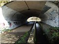
View through tunnel
The tunnel (Image), below the railway line, contains not just a footpath, but a conduit for the Dalnottar or Lusset Burn. Behind the photographer's position, it is steeper: Image
Image: © Lairich Rig
Taken: 11 Mar 2014
0.15 miles
8
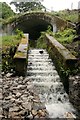
Spillway on the Dalnottar Burn
The original route of the Dalnottar Burn through Lusset Glen has been altered. Here it flows under the bridge behind, which carries the Glasgow to Dumbarton railway line.
Image: © Richard Sutcliffe
Taken: 29 Jul 2018
0.16 miles
9
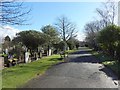
Old Dalnottar Cemetery
This is a view from near the south-western extremity of the cemetery. Click on the end-note title for related images.
Image: © Lairich Rig
Taken: 11 Mar 2014
0.16 miles
10
The Lusset
The burn that flows from the Kilpatrick Hills and gives the Glen its name.
Image: © Stephen Sweeney
Taken: 20 Jan 2008
0.17 miles