IMAGES TAKEN NEAR TO
Roman Crescent, GLASGOW, G60 5JU
Introduction
This page details the photographs taken nearby to Roman Crescent, G60 5JU by members of the Geograph project.
The Geograph project started in 2005 with the aim of publishing, organising and preserving representative images for every square kilometre of Great Britain, Ireland and the Isle of Man.

There are currently over 7.5m images from over14,400 individuals and you can help contribute to the project by visiting https://www.geograph.org.uk
Image Map (Loading...)


Getting Data...Please wait
Leaflet Map data © OpenStreetMap
Images are licensed for reuse under creativecommons.org/licenses/by-sa/2.0
Notes
- Clicking on the map will re-center to the selected point.
- The higher the marker number, the further away the image location is from the centre of the postcode.
Image Listing (92 Images Found)
Images are licensed for reuse under creativecommons.org/licenses/by-sa/2.0
Image
Details
Distance
1

Forth and Clyde Canal
Looking East on the towpath.
Image: © Gordon Dowie
Taken: 7 Nov 2010
0.07 miles
2
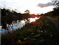
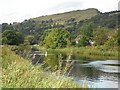
Forth & Clyde Canal, Bowling
Looking towards the Erskine Bridge on an Autumnal morning.
Image: © wfmillar
Taken: 28 Oct 2011
0.08 miles
3
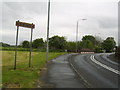
Road into Old Kilpatrick
From Bowling.
Image: © Stephen Sweeney
Taken: 11 May 2007
0.08 miles
4
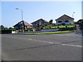
Houses on Roman Crescent
From Dumbarton Road.
Image: © Stephen Sweeney
Taken: 27 Jul 2008
0.11 miles
5
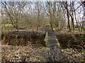
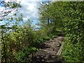
Woodland path near Bowling
Indistinctly visible through the trees on the right are the River Clyde and the Erskine Bridge.
As the map shows, the path closely follows what was once the course of a railway line; the structures crossed by the path at this point were associated with that line. See Image, another remnant of the same line.
Image: © Lairich Rig
Taken: 3 Mar 2014
0.11 miles
6
Forth and Clyde Canal
The notes for this square point out that this has some of the densest concentration of transport infrastructure in Britain, so it is a bit of surprise to find such a tranquil looking rural scene. I say looking, the A82 is all too obvious by its sound.
Image: © Richard Webb
Taken: 1 Sep 2009
0.12 miles
7
Path by the River Clyde at Old Kilpatrick
As mentioned at Image, some measures have been taken to improve the places prone to becoming muddy. Compare Image, an earlier picture of a nearby part of the path.
Image: © Lairich Rig
Taken: 13 May 2018
0.12 miles
8
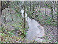
Stream from the Forth and Clyde Canal
This stream flows down from near Glenarbuck House and is unnamed on Ordnance Survey Street view maps.
Image: © Tim Glover
Taken: 31 Dec 2007
0.12 miles
9
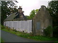
Towpath ruin
This ruin is found directly across the towpath from the bascule bridge over the Forth and Clyde Canal.
Image: © Mark Nightingale
Taken: 30 Sep 2009
0.12 miles
10
Forth and Clyde Canal
Looking towards Bowling.
Image: © Richard Sutcliffe
Taken: 29 Feb 2020
0.12 miles