IMAGES TAKEN NEAR TO
Kirkton, GLASGOW, G60 5JL
Introduction
This page details the photographs taken nearby to Kirkton, G60 5JL by members of the Geograph project.
The Geograph project started in 2005 with the aim of publishing, organising and preserving representative images for every square kilometre of Great Britain, Ireland and the Isle of Man.

There are currently over 7.5m images from over14,400 individuals and you can help contribute to the project by visiting https://www.geograph.org.uk
Image Map
Images are licensed for reuse under creativecommons.org/licenses/by-sa/2.0
Notes
- Clicking on the map will re-center to the selected point.
- The higher the marker number, the further away the image location is from the centre of the postcode.
Image Listing (128 Images Found)
Images are licensed for reuse under creativecommons.org/licenses/by-sa/2.0
Image
Details
Distance
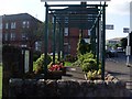
1
Garden at site of St Patrick's Well
The nearby well war reputedly used by St Patrick before he was taken to Ireland.
Image: © Stephen Sweeney
Taken: 27 Jul 2008
0.03 miles
2
Site of St Patrick's well
The sign to the left of the image gives information of the historical significance of the site.
Image: © Stephen Sweeney
Taken: 27 Jul 2008
0.03 miles
3
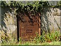
Memorial to John Clark
This iron plaque is built into the western wall of the kirkyard of Image, and its inscription is as follows: "Sacred to the memory of John Clark, calico printer, littlemill, 1776, and of his heirs 1829".
On Littlemill and its former industries, see Image and Image; the first of those links mentions the print and cotton bleaching works located there.
Image: © Lairich Rig
Taken: 26 May 2012
0.04 miles
4
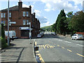
Dumbarton Road Old Kilpatrick
Looking West at Mansfield Crescent.
Image: © Thomas Nugent
Taken: 7 Aug 2010
0.04 miles
5
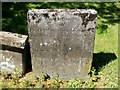
The gravestone of Robert Whitworth
The gravestone is located to the WNW of Image
"Robert Whitworth, who completed the construction of the Forth and Clyde Canal, was buried here. He died, at the age of 32 years, on 23rd July, 1802, and his wife, Jane Fleming of Dalnotter(*), died 1st August, 1807, aged 33 years" [John Bruce, "History of the Parish of West or Old Kilpatrick" (1893), page 107].
One of the sons of the English canal engineer Robert Whitworth (1734-99) was also called Robert, and he followed his father in the same line of work; it is presumably that son who is commemorated here. Aside from Robert Whitworth, the stone commemorates John Fleming Jnr., Mary Ann Whitworth, and Mary Fleming.
[(*) Dalnotter is not a typo, but an old alternative spelling of what is now usually written Dalnottar.]
Image: © Lairich Rig
Taken: 26 May 2012
0.04 miles
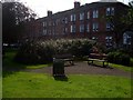
6
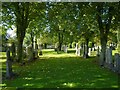
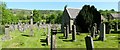
Old Kilpatrick Cemetery
This is a view towards the western boundary of the cemetery. Click on the "Old Kilpatrick Cemetery" tag – or use http://www.geograph.org.uk/tagged/Old+Kilpatrick+Cemetery – for more images.
Image: © Lairich Rig
Taken: 4 Oct 2013
0.04 miles
7
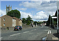
Dumbarton Road Old Kilpatrick
Looking east at Mansfield Crescent.
Image: © Thomas Nugent
Taken: 7 Aug 2010
0.05 miles
8
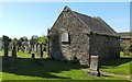
Burial place of Hamilton of Barns
The building is located just to the north-west of Image (see that item for the works that are referred to, by author, below). The inscription on the front says: "The Burial Place of the Family of Hamilton of Barns 1575-1887".
Bruce (1893) notes that "the oldest family burying vault is that of the Hamiltons of Barns and Cochno, whose possessions in the parish date from the Reformation times. It has no architectural pretensions whatever".
Although the building is of rather plain construction, it has some interesting details, such as the old carved stone head shown in Image
(There is a similar but smaller structure just to the north of this one; it is labelled "mortuary" on early OS maps. The area in which the Hamilton of Barns vault and the mortuary are located was originally the north-western corner of the kirkyard; however, the latter was extended in 1878 by the purchase of additional land.)
For detailed information about the Hamiltons of Barns and Cochno, see pages 274-282 of [Bruce]. Cochno is still familiar as a place-name today (Image), and was in the hands of the Hamilton family by the middle of the sixteenth century.
As for the lands of Barns, parts of them (namely, west Barns of Clyde) were feued from the Hamiltons(*) c.1870 by Messrs J and G Thomson, who had been obliged to move from their Glasgow site. The firm had operated a Clydebank Foundry in Glasgow, and they brought the name Clydebank with them, using it for the new yard that they erected at Barns of Clyde. Clydebank Terrace was the first of the tenements built for the shipyard workers; it dated from the early 1870s, and was popularly known as Tamson's Toon (i.e., Thomson's Town). At that early period, it could not really be said that there was yet a "town of Clydebank"; at least, those who lived there would not yet have thought of it in those terms. However, when the Burgh of Clydebank was formed in 1886, it took its name from the shipyard (see page 282 of [Bruce]).
(*) Specifically, the land was feued from Grace Hamilton, who lived at Cochno House, and who died unmarried in 1887. She gave generously to a number of fine causes; she is also commemorated in the name of Hamilton Free Church in Clydebank.
Image: © Lairich Rig
Taken: 26 May 2012
0.05 miles
9
Kirkyard of Old Kilpatrick Parish Church
This is the part of the kirkyard to the west and north-west of Image The nearby structure on the right is the Image
The kirkyard was originally smaller than it is today; the Barns of Hamilton vault stands near what was originally its north-western corner. The area in the middle distance, on the left, in front of the opening in the wall, was not originally a part of the kirkyard, but the latter was extended in 1878. The opening is the Image; see that item for more on the extension of the kirkyard.
Near the right-hand edge of the photograph, note that the top of a tall memorial can be seen in front of the end-wall of a house. This is one of the tallest memorials in the kirkyard, but the inscriptions on it are hidden from view, and visitors may therefore wonder whom it commemorates; in fact, it is Image, commemorating Colonel Andrew Geils of Dumbuck, Captain John Edward Geils, and several others. For more on that family, see the link just given, as well as the final few paragraphs of the description of Image; see also Image
Image: © Lairich Rig
Taken: 26 May 2012
0.05 miles
10
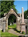
Entrance to Old Kilpatrick Cemetery
The picture was taken from what is presently the north-western part of the Image See Image for the main description.
The kirkyard was originally smaller. It was rectangular in shape; the original northern wall is the one that can be seen behind the Image, and the original western wall is the one into which the Image is built. The continuations of those walls intersect at about Image, which was the original north-western corner of the kirkyard.
However, demand for lairs increased, and additional ground was purchased from Lord Blantyre. This allowed for the extension of the kirkyard in 1878. The additional ground, which lies to the north and the north-west of the church, includes this area on the near side of the entrance; that is why the date 1878 is inscribed above it.
The date 1909 is written above the opposite side of the entrance, where Old Kilpatrick Cemetery is located: Image
Image: © Lairich Rig
Taken: 26 May 2012
0.05 miles