Kirkyard of Old Kilpatrick Parish Church
Introduction
The photograph on this page of Kirkyard of Old Kilpatrick Parish Church by Lairich Rig as part of the Geograph project.
The Geograph project started in 2005 with the aim of publishing, organising and preserving representative images for every square kilometre of Great Britain, Ireland and the Isle of Man.

There are currently over 7.5m images from over 14,400 individuals and you can help contribute to the project by visiting https://www.geograph.org.uk
Kirkyard of Old Kilpatrick Parish Church
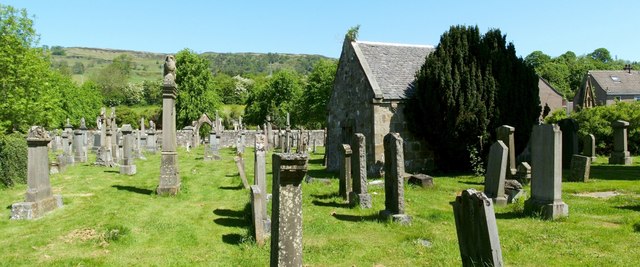
Image: © Lairich Rig Taken: 26 May 2012
This is the part of the kirkyard to the west and north-west of Image The nearby structure on the right is the Image The kirkyard was originally smaller than it is today; the Barns of Hamilton vault stands near what was originally its north-western corner. The area in the middle distance, on the left, in front of the opening in the wall, was not originally a part of the kirkyard, but the latter was extended in 1878. The opening is the Image; see that item for more on the extension of the kirkyard. Near the right-hand edge of the photograph, note that the top of a tall memorial can be seen in front of the end-wall of a house. This is one of the tallest memorials in the kirkyard, but the inscriptions on it are hidden from view, and visitors may therefore wonder whom it commemorates; in fact, it is Image, commemorating Colonel Andrew Geils of Dumbuck, Captain John Edward Geils, and several others. For more on that family, see the link just given, as well as the final few paragraphs of the description of Image; see also Image
Images are licensed for reuse under creativecommons.org/licenses/by-sa/2.0
Image Location
Latitude
55.926342
Longitude
-4.4612