IMAGES TAKEN NEAR TO
Kilpatrick Court, GLASGOW, G60 5JA
Introduction
This page details the photographs taken nearby to Kilpatrick Court, G60 5JA by members of the Geograph project.
The Geograph project started in 2005 with the aim of publishing, organising and preserving representative images for every square kilometre of Great Britain, Ireland and the Isle of Man.

There are currently over 7.5m images from over14,400 individuals and you can help contribute to the project by visiting https://www.geograph.org.uk
Image Map
Images are licensed for reuse under creativecommons.org/licenses/by-sa/2.0
Notes
- Clicking on the map will re-center to the selected point.
- The higher the marker number, the further away the image location is from the centre of the postcode.
Image Listing (121 Images Found)
Images are licensed for reuse under creativecommons.org/licenses/by-sa/2.0
Image
Details
Distance
1
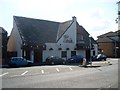
The Ettrick Bar, Old Kilpatrick
Like many of the small villages in this area, Old Kilpatrick has an unusually high number of pubs.
Image: © Stephen Sweeney
Taken: 27 Jul 2008
0.04 miles
2
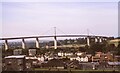
View across Old Kilpatrick towards the Erskine Bridge - July 1993
View across Old Kilpatrick towards the Erskine Bridge (in grid square NS4672) from the side of the A82 in grid square NS4673.
Wikipedia: https://en.wikipedia.org/wiki/Erskine_Bridge
Camera: Canon AE-1 Program
Film: Agfachrome
Scanned using a CanoScan 9000F Mark II
Image: © Jeff Buck
Taken: 13 Jul 1993
0.04 miles
3
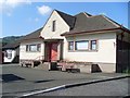
Napier Hall
Community hall in the village of Old Kilpatrick.
Image: © Stephen Sweeney
Taken: 27 Jul 2008
0.05 miles


6
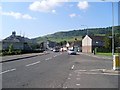
Dumbarton Road approaching Old Kilpatrick village
Image: © Stephen Sweeney
Taken: 27 Jul 2008
0.05 miles
7
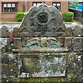
Mural tablet (Stirling of Law burial place)
This stone is set in the southern wall of the Image, at the south-eastern corner of the kirkyard of Image See the first of those links for the text on the tablet, which identifies 1658 as the year in which the enclosure was erected.
At the top is what appears to be a monogram, set in what is perhaps intended to be a miller's rind symbol (alternatively, the similarity may be accidental).
Image: © Lairich Rig
Taken: 8 Jun 2012
0.05 miles
8
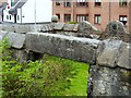
Carved stone (Stirling of Law burial place)
This stone is on the northern side of the Image, at the south-eastern corner of the kirkyard of Image (see that link for the reference cited below).
The stone is illustrated and described on pages 104-105 of [Bruce], written in 1893: "over the doorway is carved the arms of Stirling and Maxwell per pale with the initials WS & MM 1659". These are arranged as follows: "W" above "M" above "16" to the left of the combined arms, and "S" above "M" above "59" to the right (except that the figure 39 has been carved where the "S" used to be; however, that letter had already worn away by the time Bruce wrote his book).
In the background, on the right, is the top and the "winged soul" (these are often misinterpreted as cherubs) of a mural tablet associated with the same enclosure: Image
Image: © Lairich Rig
Taken: 8 Jun 2012
0.05 miles
9
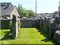
Burial place of Stirling of Law
This is the south-eastern corner of the kirkyard of Image Although the wall on the right is in shadow, it should be possible to discern that it incorporates a mural tablet: Image Its inscription reads:
"THIS IS THE BURIAL PLACE
APOYNTED FOR WILLIAM
STIRLING OF LAW HIS
WYFE AND CHILDREIN
MAY 26 1658"
John Bruce, on pages 104-105 of his "History of the Parish of West or Old Kilpatrick" (1893), says that "a mural tablet in Stirling of Law's tomb gives the date of 1658 as time of erection, while over the doorway is carved the arms of Stirling and Maxwell per pale with the initials W S & M M 1659"; he also includes an illustration of the latter stone, which is located above an opening on the left side-wall of this area, and which is shown at Image
(On the initials WS and MM that are carved into both stones, see below.)
An effigy of a knight, which is now attached to the church wall, had previously been located here, although it may earlier have been inside the church itself: Image
The lands of Law (Image) adjoined those of Edenbarnet (or Edinbarnet) and Craigbanzeoch; "the adjoining lands of Law formed part of the lordship of Drumry and were acquired by William Stirling, first of Glorat, in 1528, from Sir James Hamilton of Finnart with consent of his spouse, Margaret Livingston, heiress of the Drumry and neighbouring lands, on 28th November, 1530" [John Bruce, on page 287 of his "History of the Parish of West or Old Kilpatrick" (1893)].
After giving the details of intervening generations of the family, the same work notes that William, fifth of Law, one of the commissioners of the county, married Margaret Maxwell of Dargavel (hence the WS and MM initials on the mural tablet). He left three daughters, but the direct line of male descent ended in him. At some time (a number of years before Bruce's book was written), there had been a Law Tower, but the stones from its ruins were carted away by the tenant of Law Farm, and some of them were used in making repairs at Old Edenbarnet House.
The Pont/Blaeu map of the Lennox, published in 1654, shows Law, with Edinbarnet marked nearby. Roy's Military Survey of Scotland (1740-50s) also includes it, as Lawes, near Inbarnett (Edinbarnet). Roy also shows a Muirlee nearby, which is depicted as a ruin (Muirlees) on the first-edition OS map (c.1860).
In the background, on the right, is Dumbarton Road, the main road through Old Kilpatrick.
Image: © Lairich Rig
Taken: 26 May 2012
0.06 miles
10
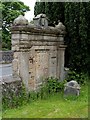
Mural tablet (MacNair family)
This large tablet is located near the south-eastern corner of the kirkyard of Image (see that item for the references cited below), and is set in the southern boundary wall, next to the Image
The tablet is described in the list of pre-1855 inscriptions (see the references) as being of reredos type. The text has largely flaked off, and only fragments remain. However, the tablet is a memorial for the MacNair (or McNair) family of Kilbowie. [Bruce], on page 284, gives as much of the inscription as was legible in the 1890s; readers may spot that a "for" seems to be missing ("burying place appointed Robert McNair"), but I have given the text just as it appears in Bruce's book:
"MEMENTO MORI
This is the burying place of Robert McNair, Portioner in Wester Kilbowie and Dalmure, who died July 18th, 1675, aged 64 years.
Thomas McNair, late Tenant in Barns of Clyde, who died June [ ], 17[ ], aged 74.
This is the burying place appointed Robert McNair, Tenant in the Mains of Scotstoun, his wife and children, A.D. MDC[ ]"
Kilbowie: c.Image Dalmure: now spelled Dalmuir (Image). Barns of Clyde: see Image Scotstoun: c.Image
At the top of the tablet is an hourglass, flanked by Latin text: Image
Image: © Lairich Rig
Taken: 8 Jun 2012
0.06 miles