Burial place of Stirling of Law
Introduction
The photograph on this page of Burial place of Stirling of Law by Lairich Rig as part of the Geograph project.
The Geograph project started in 2005 with the aim of publishing, organising and preserving representative images for every square kilometre of Great Britain, Ireland and the Isle of Man.

There are currently over 7.5m images from over 14,400 individuals and you can help contribute to the project by visiting https://www.geograph.org.uk
Burial place of Stirling of Law
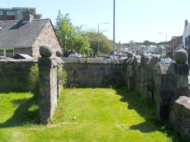
Image: © Lairich Rig Taken: 26 May 2012
This is the south-eastern corner of the kirkyard of Image Although the wall on the right is in shadow, it should be possible to discern that it incorporates a mural tablet: Image Its inscription reads: "THIS IS THE BURIAL PLACE APOYNTED FOR WILLIAM STIRLING OF LAW HIS WYFE AND CHILDREIN MAY 26 1658" John Bruce, on pages 104-105 of his "History of the Parish of West or Old Kilpatrick" (1893), says that "a mural tablet in Stirling of Law's tomb gives the date of 1658 as time of erection, while over the doorway is carved the arms of Stirling and Maxwell per pale with the initials W S & M M 1659"; he also includes an illustration of the latter stone, which is located above an opening on the left side-wall of this area, and which is shown at Image (On the initials WS and MM that are carved into both stones, see below.) An effigy of a knight, which is now attached to the church wall, had previously been located here, although it may earlier have been inside the church itself: Image The lands of Law (Image) adjoined those of Edenbarnet (or Edinbarnet) and Craigbanzeoch; "the adjoining lands of Law formed part of the lordship of Drumry and were acquired by William Stirling, first of Glorat, in 1528, from Sir James Hamilton of Finnart with consent of his spouse, Margaret Livingston, heiress of the Drumry and neighbouring lands, on 28th November, 1530" [John Bruce, on page 287 of his "History of the Parish of West or Old Kilpatrick" (1893)]. After giving the details of intervening generations of the family, the same work notes that William, fifth of Law, one of the commissioners of the county, married Margaret Maxwell of Dargavel (hence the WS and MM initials on the mural tablet). He left three daughters, but the direct line of male descent ended in him. At some time (a number of years before Bruce's book was written), there had been a Law Tower, but the stones from its ruins were carted away by the tenant of Law Farm, and some of them were used in making repairs at Old Edenbarnet House. The Pont/Blaeu map of the Lennox, published in 1654, shows Law, with Edinbarnet marked nearby. Roy's Military Survey of Scotland (1740-50s) also includes it, as Lawes, near Inbarnett (Edinbarnet). Roy also shows a Muirlee nearby, which is depicted as a ruin (Muirlees) on the first-edition OS map (c.1860). In the background, on the right, is Dumbarton Road, the main road through Old Kilpatrick.
Images are licensed for reuse under creativecommons.org/licenses/by-sa/2.0
Image Location
Latitude
55.925819
Longitude
-4.460366