IMAGES TAKEN NEAR TO
Barra Road, GLASGOW, G60 5HS
Introduction
This page details the photographs taken nearby to Barra Road, G60 5HS by members of the Geograph project.
The Geograph project started in 2005 with the aim of publishing, organising and preserving representative images for every square kilometre of Great Britain, Ireland and the Isle of Man.

There are currently over 7.5m images from over14,400 individuals and you can help contribute to the project by visiting https://www.geograph.org.uk
Image Map (Loading...)


Getting Data...Please wait
Leaflet Map data © OpenStreetMap
Images are licensed for reuse under creativecommons.org/licenses/by-sa/2.0
Notes
- Clicking on the map will re-center to the selected point.
- The higher the marker number, the further away the image location is from the centre of the postcode.
Image Listing (13 Images Found)
Images are licensed for reuse under creativecommons.org/licenses/by-sa/2.0
Image
Details
Distance
1

Trees and night sky over Mountblow
The town of Clydebank would be clearly visible, if not for the trees.
Image: © Stephen Sweeney
Taken: 16 Jan 2008
0.10 miles
2
Freelands Road
Runs into the Freelands area of Old Kilpatrick.
Image: © Stephen Sweeney
Taken: 20 Apr 2009
0.15 miles
3

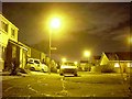
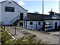
Morning Noon & Night
Convenience store in Freelands Place, Mountblow.
Image: © Barbara Carr
Taken: 18 Apr 2013
0.17 miles
4
Harris Crescent, Old Kilpatrick
The official name of this area is Antonine Park, but it is still known generally as "the new estate", despite now being around fifteen years old.
Image: © Stephen Sweeney
Taken: 16 Jan 2008
0.21 miles
5
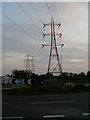
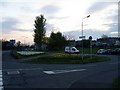
Freelands roundabout
And electricity pylons.
Image: © Stephen Sweeney
Taken: 20 Apr 2009
0.21 miles
6
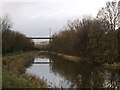
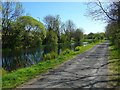
West along canal, Dalmuir
Looking west to the Erskine Bridge from the Forth and Clyde Canal bank.
Image: © Stephen Sweeney
Taken: 24 Jan 2006
0.21 miles
9
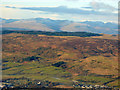
Kilpatrick Hills from the air
Carleith is on the right, Craigleith is amongst the cluster of trees on the left. The forest is at Creigarestie.
Image: © Thomas Nugent
Taken: 11 Dec 2017
0.23 miles