IMAGES TAKEN NEAR TO
Skye Crescent, GLASGOW, G60 5ER
Introduction
This page details the photographs taken nearby to Skye Crescent, G60 5ER by members of the Geograph project.
The Geograph project started in 2005 with the aim of publishing, organising and preserving representative images for every square kilometre of Great Britain, Ireland and the Isle of Man.

There are currently over 7.5m images from over14,400 individuals and you can help contribute to the project by visiting https://www.geograph.org.uk
Image Map
Images are licensed for reuse under creativecommons.org/licenses/by-sa/2.0
Notes
- Clicking on the map will re-center to the selected point.
- The higher the marker number, the further away the image location is from the centre of the postcode.
Image Listing (16 Images Found)
Images are licensed for reuse under creativecommons.org/licenses/by-sa/2.0
Image
Details
Distance
1
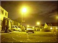
Harris Crescent, Old Kilpatrick
The official name of this area is Antonine Park, but it is still known generally as "the new estate", despite now being around fifteen years old.
Image: © Stephen Sweeney
Taken: 16 Jan 2008
0.12 miles
2
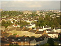
View across Clydebank from the Erskine Bridge
Close view of Old Kilpatrick in the foreground.
Image: © Stephen Sweeney
Taken: 20 May 2007
0.15 miles
3
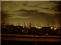
Trees and night sky over Mountblow
The town of Clydebank would be clearly visible, if not for the trees.
Image: © Stephen Sweeney
Taken: 16 Jan 2008
0.15 miles
4
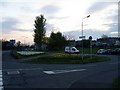
Freelands Road
Runs into the Freelands area of Old Kilpatrick.
Image: © Stephen Sweeney
Taken: 20 Apr 2009
0.16 miles
5
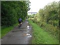
Forth and Clyde Canal
The towpath carries a long established cycle path from Glasgow to Balloch. Approaching the Erskine Bridge along a well wooded section of the canal.
Image: © Richard Webb
Taken: 1 Sep 2009
0.17 miles
7
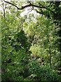
Vegetation beside the Forth and Clyde Canal
Dense, largely ash woodland between the canal and the site of a fuel depot.
Image: © Richard Webb
Taken: 1 Sep 2009
0.19 miles
8
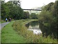
Forth and Clyde Canal
Approaching the Erskine Bridge along the canal towpath, now a cycle path (NCN 7)
Image: © Richard Webb
Taken: 1 Sep 2009
0.19 miles
9
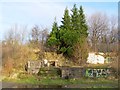
Steps beside footbridge
The steps shown here lead up to an old footbridge across a now Image; the footbridge gives access to the footpath and cycle route that runs along the south-western side of the Image The canal is less than 60 metres from the base of the steps.
These steps stand alongside the path that is shown in Image The footbridge itself was built in the late nineteenth century, but the structures that are shown in the present photograph will have been built (or at least modified) later, in connection with the fuel depot.
Image: © Lairich Rig
Taken: 9 Dec 2011
0.20 miles
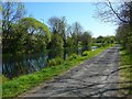
10
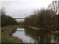
West along canal, Dalmuir
Looking west to the Erskine Bridge from the Forth and Clyde Canal bank.
Image: © Stephen Sweeney
Taken: 24 Jan 2006
0.21 miles