IMAGES TAKEN NEAR TO
Freelands Place, GLASGOW, G60 5ED
Introduction
This page details the photographs taken nearby to Freelands Place, G60 5ED by members of the Geograph project.
The Geograph project started in 2005 with the aim of publishing, organising and preserving representative images for every square kilometre of Great Britain, Ireland and the Isle of Man.

There are currently over 7.5m images from over14,400 individuals and you can help contribute to the project by visiting https://www.geograph.org.uk
Image Map
Images are licensed for reuse under creativecommons.org/licenses/by-sa/2.0
Notes
- Clicking on the map will re-center to the selected point.
- The higher the marker number, the further away the image location is from the centre of the postcode.
Image Listing (19 Images Found)
Images are licensed for reuse under creativecommons.org/licenses/by-sa/2.0
Image
Details
Distance
1
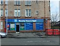
Morning Noon & Night
Convenience store in Freelands Place, Mountblow.
Image: © Barbara Carr
Taken: 18 Apr 2013
0.01 miles
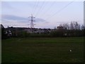
2
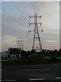
Freelands roundabout
And electricity pylons.
Image: © Stephen Sweeney
Taken: 20 Apr 2009
0.06 miles
3
Freelands Road
Runs into the Freelands area of Old Kilpatrick.
Image: © Stephen Sweeney
Taken: 20 Apr 2009
0.09 miles
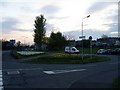
4
Mountblow from Freelands Roundabout
Image: © Stephen Sweeney
Taken: 20 Apr 2009
0.12 miles
5
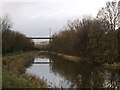
West along canal, Dalmuir
Looking west to the Erskine Bridge from the Forth and Clyde Canal bank.
Image: © Stephen Sweeney
Taken: 24 Jan 2006
0.13 miles
6
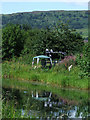
"Sitooterie" by the Forth & Clyde Canal
A number of residents of these canal-side bungalows have extended platforms on to the canal banks on which to sit out on in fine weather.
Image: © Gordon Brown
Taken: 8 May 2017
0.14 miles
7
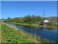
Forth & Clyde Canal
With a small forest of Scotland flags on display in a private garden, with the Kilpatrick Hills in the background.
Image: © Thomas Nugent
Taken: 7 Aug 2010
0.14 miles
8
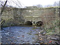
Burn underpassing Canal in Dalmuir
The small bridge allows the artificial canal to pass over the natural burn.
Image: © Stephen Sweeney
Taken: 24 Jan 2007
0.14 miles
9
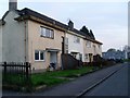
Brisbane Street housing
Small residential street that runs for just about 100 yards between Dumbarton Road and Canberra Avenue.
Image: © Stephen Sweeney
Taken: 20 Apr 2009
0.18 miles
10
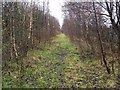
Dismantled railway line
The clearing indicates the course that was followed by the Lanarkshire and Dumbarton railway line; see Image for further details.
Here, the line was lower than its surroundings, and its course resembles a canal after prolonged periods of rainy weather. Not far to the left (north-east) is an actual canal (the Image); just to the right (south-west) of the dismantled line, but concealed by the trees, is a path (Image), and an area of waste ground that was formerly occupied by the Admiralty's fuel depot: http://www.geograph.org.uk/snippet/6052
Image: © Lairich Rig
Taken: 17 Nov 2011
0.20 miles